
Haz una donación
Equípate para tu próxima aventura:
Como asociado de Amazon, este sitio gana comisiones por las compras que califican, sin ningún costo adicional para usted.
Mapa topográfico Hood River
Haga clic en el mapa para ver la altitud.
Haz una donación
Equípate para tu próxima aventura:
Como asociado de Amazon, este sitio gana comisiones por las compras que califican, sin ningún costo adicional para usted.
Hood River
Temperatures for the year as a whole are slightly cooler than in most other low-elevation towns in the region, especially at night because of air drainage off the surrounding mountains.
Haz una donación
Equípate para tu próxima aventura:
Como asociado de Amazon, este sitio gana comisiones por las compras que califican, sin ningún costo adicional para usted.
Acerca de este mapa
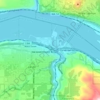
Nombre: Mapa topográfico Hood River, altitud, relieve.
Lugar: Hood River, Hood River County, Oregon, United States (45.69298 -121.56508 45.72651 -121.49538)
Altitud media: 112 m
Altitud mínima: 14 m
Altitud máxima: 504 m
Haz una donación
Equípate para tu próxima aventura:
Como asociado de Amazon, este sitio gana comisiones por las compras que califican, sin ningún costo adicional para usted.
Otros mapas topográficos
Haga clic en un mapa para ver su topografía, su altitud y su relieve.
Mount Hood
United States > Oregon > Hood River County
Timberline Lodge is a National Historic Landmark located on the southern flank of Mount Hood just below Palmer Glacier, with an elevation of about 6,000 ft (1,800 m).
Altitud media: 2.716 m
Mount Hood
United States > Oregon > Hood River County
Timberline Lodge is a National Historic Landmark located on the southern flank of Mount Hood just below Palmer Glacier, with an elevation of about 6,000 ft (1,800 m).
Altitud media: 2.716 m
Mount Hood
United States > Oregon > Hood River County
Mount Hood, also known as Wy'east, is an active stratovolcano in the Cascade Range and is a member of the Cascade Volcanic Arc. It was formed by a subduction zone on the Pacific Coast and rests in the Pacific Northwest region of the United States. It is located about 50 miles (80 km) east-east-southeast of…
Altitud media: 2.716 m
Haz una donación
Equípate para tu próxima aventura:
Como asociado de Amazon, este sitio gana comisiones por las compras que califican, sin ningún costo adicional para usted.