
Haz una donación
Equípate para tu próxima aventura:
Como asociado de Amazon, este sitio gana comisiones por las compras que califican, sin ningún costo adicional para usted.
Mapa topográfico Andover
Haga clic en el mapa para ver la altitud.
Haz una donación
Equípate para tu próxima aventura:
Como asociado de Amazon, este sitio gana comisiones por las compras que califican, sin ningún costo adicional para usted.
Andover
According to the United States Census Bureau, the town has a total area of 41.4 square miles (107.3 km2), of which 40.5 sq mi (105.0 km2) is land and 0.89 sq mi (2.3 km2) is water, comprising 2.14% of the town. Andover is drained by the Blackwater River. Bradley Lake is in the south. Ragged Mountain, elevation 2,286 feet (697 m) above sea level, is on the northern boundary. The northern slopes of Mount Kearsarge occupy the southernmost part of town and contain the town's highest point, 2,460 ft (750 m) above sea level. Andover lies fully within the Merrimack River watershed.
Haz una donación
Equípate para tu próxima aventura:
Como asociado de Amazon, este sitio gana comisiones por las compras que califican, sin ningún costo adicional para usted.
Acerca de este mapa
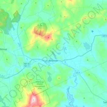
Nombre: Mapa topográfico Andover, altitud, relieve.
Lugar: Andover, Merrimack County, New Hampshire, United States (43.38902 -71.89415 43.50299 -71.69456)
Altitud media: 301 m
Altitud mínima: 164 m
Altitud máxima: 886 m
Haz una donación
Equípate para tu próxima aventura:
Como asociado de Amazon, este sitio gana comisiones por las compras que califican, sin ningún costo adicional para usted.
Otros mapas topográficos
Haga clic en un mapa para ver su topografía, su altitud y su relieve.