
Mapa topográfico Buzău
Mapa interactivo
Haga clic en el mapa para ver la altitud.
Acerca de este mapa
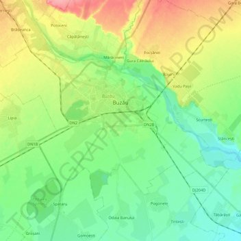
Nombre: Mapa topográfico Buzău, altitud, relieve.
Lugar: Buzău, Romania (45.09161 26.71469 45.18375 26.92587)
Altitud media: 96 m
Altitud mínima: 66 m
Altitud máxima: 152 m
The city is located in the center of the county, 100 km north-east of Bucharest, in the South-East of Romania, taking up a total area of 81,3 km2, at the outermost curvature of the Subcarpathian foothills, at the crossroads of the three main Romanian historical provinces: Wallachia, Transylvania and Moldavia. It is entirely placed on the right bank of Buzău river, which forms its northern limit. The shape of the city is oblong, longer along the river and shorter across. It reaches altitudes of 101 meters in the North-West, near the foothills, going down to 88 meters on the river bank, while the average altitude of 95 meters is the same as the altitude of Dacia square, in the city center. Thus, Buzău is placed in a flat area, with a height difference of just 10 meters along a 4 kilometer line.
Otros mapas topográficos
Haga clic en un mapa para ver su topografía, su altitud y su relieve.
Bâsca Chiojdului
Bâsca Chiojdului, Chiojdu, Buzău, 127171, Romania
Altitud media: 732 m
Vadu Oii
Romania > Buzău > Gura Teghii
Vadu Oii, Gura Teghii, Buzău, 127286, Romania
Altitud media: 819 m