
Mapa topográfico Wuzhong City
Mapa interactivo
Haga clic en el mapa para ver la altitud.
Acerca de este mapa
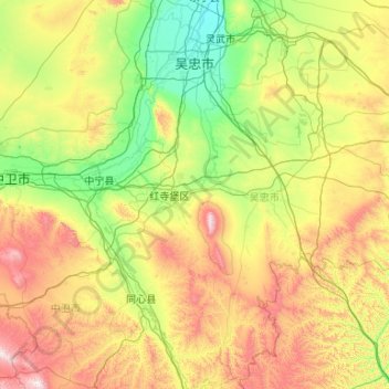
Nombre: Mapa topográfico Wuzhong City, altitud, relieve.
Lugar: Wuzhong City, Ningxia, China (36.57858 105.55570 38.26078 107.65254)
Altitud media: 1.493 m
Altitud mínima: 1.109 m
Altitud máxima: 2.618 m
Topography: Wuzhong city is long from east to west and narrow from north to south. The topography is high in the south and low in the north, with Yinchuan plain in the north and Qingtongxia plain and hilly land in the south. Sichuan district dry average elevation of 1100 meters, the mountain elevation of 1300–1900 meters. The city's landform is made up of loess plateau, ordos platform, Yellow River alluvial plain and l mountain.