
Haz una donación
Equípate para tu próxima aventura:
Como asociado de Amazon, este sitio gana comisiones por las compras que califican, sin ningún costo adicional para usted.
Mapa topográfico Mayne
Haga clic en el mapa para ver la altitud.
Haz una donación
Equípate para tu próxima aventura:
Como asociado de Amazon, este sitio gana comisiones por las compras que califican, sin ningún costo adicional para usted.
Acerca de este mapa
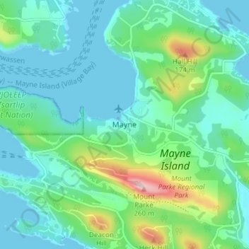
Nombre: Mapa topográfico Mayne, altitud, relieve.
Altitud media: 52 m
Altitud mínima: 0 m
Altitud máxima: 241 m
Haz una donación
Equípate para tu próxima aventura:
Como asociado de Amazon, este sitio gana comisiones por las compras que califican, sin ningún costo adicional para usted.
Otros mapas topográficos
Haga clic en un mapa para ver su topografía, su altitud y su relieve.
Galiano Island
Canada > British Columbia > Capital Regional District > Southern Gulf Islands Electoral Area
Altitud media: 24 m
North Pender Island
Canada > British Columbia > Capital Regional District > Southern Gulf Islands Electoral Area
Altitud media: 23 m
Portland Island
Canada > British Columbia > Capital Regional District > Southern Gulf Islands Electoral Area
Altitud media: 7 m
Mayne Island
Canada > British Columbia > Capital Regional District > Southern Gulf Islands Electoral Area > Mayne
Altitud media: 26 m
Haz una donación
Equípate para tu próxima aventura:
Como asociado de Amazon, este sitio gana comisiones por las compras que califican, sin ningún costo adicional para usted.
James Island
Canada > British Columbia > Capital Regional District > Southern Gulf Islands Electoral Area
James Island, one of British Columbia's Gulf Islands, lies in Haro Strait between Sidney Island and the coast of Vancouver Island near Sidney, British Columbia. James Island is approximately 2.4 km (1.5 mi) from the coast of Vancouver Island, and 145 km (90 mi) from Seattle, Washington. James Island has an…
Altitud media: 8 m
Piers Island
Canada > British Columbia > Capital Regional District > Southern Gulf Islands Electoral Area
Altitud media: 4 m
Saturna Island
Canada > British Columbia > Capital Regional District > Southern Gulf Islands Electoral Area
Altitud media: 34 m
Haz una donación
Equípate para tu próxima aventura:
Como asociado de Amazon, este sitio gana comisiones por las compras que califican, sin ningún costo adicional para usted.
Buck Lake
Canada > British Columbia > Capital Regional District > Southern Gulf Islands Electoral Area
Altitud media: 58 m
Pym Island
Canada > British Columbia > Capital Regional District > Southern Gulf Islands Electoral Area
Altitud media: 2 m
Haro Strait
Canada > British Columbia > Capital Regional District > Southern Gulf Islands Electoral Area
Altitud media: 24 m
Mayne Island
Canada > British Columbia > Capital Regional District > Southern Gulf Islands Electoral Area > Mayne
Altitud media: 26 m
Haz una donación
Equípate para tu próxima aventura:
Como asociado de Amazon, este sitio gana comisiones por las compras que califican, sin ningún costo adicional para usted.
Sidney Island
Canada > British Columbia > Capital Regional District > Southern Gulf Islands Electoral Area
Sidney Island is one of the southern Gulf Islands located between the southwest coast of British Columbia, Canada and Vancouver Island, BC, near James Island. Sidney Island has an elevation of 77 metres (252 feet 8 inches) above mean sea level at its highest point. It is located across Sidney Channel, just…
Altitud media: 7 m