
Mapa topográfico East Sussex
Mapa interactivo
Haga clic en el mapa para ver la altitud.
Acerca de este mapa
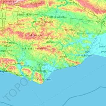
Nombre: Mapa topográfico East Sussex, altitud, relieve.
Lugar: East Sussex, England, United Kingdom (50.73343 -0.24508 51.14746 0.86786)
Altitud media: 44 m
Altitud mínima: -2 m
Altitud máxima: 270 m
The chalk uplands of the South Downs occupies the coastal strip between Brighton and Eastbourne. There are two river gaps: the Rivers Ouse and Cuckmere. The Seven Sisters, where the Downs meet the sea, are the remnants of dry valleys cut into the chalk; they end at Beachy Head, 530 feet (162 m) above sea level. To the east of Beachy Head lie the marshlands of the Pevensey Levels, formerly flooded by the sea but now enclosed within a deposited beach. At Bexhill the land begins to rise again where the sands and clays of the Weald meet the sea; these culminate in the sandstone cliffs east of Hastings. Further east are the Pett Levels, more marshland, beyond which is the estuary of the River Rother. On the far side of the estuary are the dunes of Camber Sands. The highest point in the county is Ditchling Beacon on the South Downs, which has a maximum elevation of 248 m (814 ft) and is classed as a Marilyn.
Otros mapas topográficos
Haga clic en un mapa para ver su topografía, su altitud y su relieve.
Battle
United Kingdom > England > East Sussex > Rother
Battle, Rother, East Sussex, England, United Kingdom
Altitud media: 66 m
Uckfield
United Kingdom > England > East Sussex > Wealden
Uckfield, Wealden, East Sussex, England, United Kingdom
Altitud media: 36 m
Danehill
United Kingdom > England > East Sussex > Wealden District
Danehill, Wealden District, East Sussex, England, RH17 7ET, United Kingdom
Altitud media: 81 m
Hastings
United Kingdom > England > East Sussex
Hastings, East Sussex, England, United Kingdom
Altitud media: 36 m