
Mapa topográfico Cochrane
Mapa interactivo
Haga clic en el mapa para ver la altitud.
Cochrane
Until 1977, Timmins was used as the source for all weather readings attributed to Cochrane except for exceptional extremes, due to the overall similar climate due to proximity and topography. However, in December 1977, Cochrane temperature readings began to be taken from downtown after a noticeable difference in temperature was recorded two years prior in January 1976. However, to this day, if Cochrane's weather equipment fails at any time, the Timmins temperature readings are used due to the overall similarity.
Acerca de este mapa
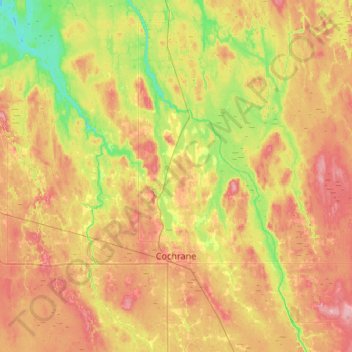
Nombre: Mapa topográfico Cochrane, altitud, relieve.
Altitud media: 262 m
Altitud mínima: 216 m
Altitud máxima: 311 m