
Mapa topográfico Creekside Park
Mapa interactivo
Haga clic en el mapa para ver la altitud.
Acerca de este mapa
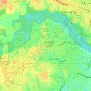
Nombre: Mapa topográfico Creekside Park, altitud, relieve.
Altitud media: 46 m
Altitud mínima: 29 m
Altitud máxima: 61 m
Otros mapas topográficos
Haga clic en un mapa para ver su topografía, su altitud y su relieve.
East Shore
United States of America > Texas > The Woodlands > East Shore
East Shore, The Woodlands, Montgomery County, Texas, 77380, United States of America
Altitud media: 45 m