
Mapa topográfico Garelochhead
Mapa interactivo
Haga clic en el mapa para ver la altitud.
Acerca de este mapa
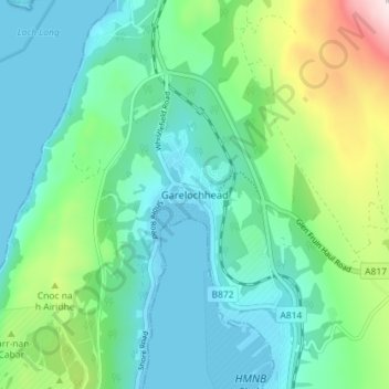
Nombre: Mapa topográfico Garelochhead, altitud, relieve.
Altitud media: 110 m
Altitud mínima: -1 m
Altitud máxima: 475 m
Otros mapas topográficos
Haga clic en un mapa para ver su topografía, su altitud y su relieve.
Island of Danna
Vereinigtes Königreich > Schottland > Argyll and Bute
Island of Danna, Argyll and Bute, Schottland, Vereinigtes Königreich
Altitud media: 9 m
Foreland
Vereinigtes Königreich > Schottland > Argyll and Bute
Foreland, Argyll and Bute, Schottland, PA49 7UU, Vereinigtes Königreich
Altitud media: 32 m
Baile Mòr
Vereinigtes Königreich > Schottland > Argyll and Bute
Baile Mòr, Argyll and Bute, Schottland, PA76 6SJ, Vereinigtes Königreich
Altitud media: 12 m
Oban
Vereinigtes Königreich > Schottland > Argyll and Bute
Oban, Argyll and Bute, Schottland, PA34 5PZ, Vereinigtes Königreich
Altitud media: 47 m
Appin
Vereinigtes Königreich > Schottland > Argyll and Bute
Appin, Argyll and Bute, Schottland, PA38 4DB, Vereinigtes Königreich
Altitud media: 93 m
North Connel
Vereinigtes Königreich > Schottland > Argyll and Bute
North Connel, Argyll and Bute, Schottland, PA37 1PL, Vereinigtes Königreich
Altitud media: 19 m