
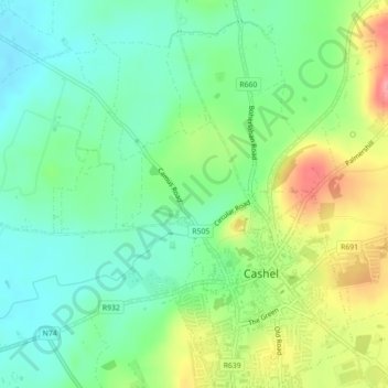
Mapa topográfico St. Patricksrock
Mapa interactivo
Haga clic en el mapa para ver la altitud.
Acerca de este mapa
Nombre: Mapa topográfico St. Patricksrock, altitud, relieve.
Altitud media: 101 m
Altitud mínima: 67 m
Altitud máxima: 162 m
Otros mapas topográficos
Haga clic en un mapa para ver su topografía, su altitud y su relieve.
Acantilados de Moher
Acantilados de Moher, Ballysteen ED, West Clare Municipal District, Condado de Clare, Munster, Irlanda
Altitud media: 55 m
Killarney
Killarney, Killarney Municipal District, Condado de Kerry, Munster, Irlanda
Altitud media: 57 m
Kenmare Municipal District
Kenmare Municipal District, Condado de Kerry, Munster, Irlanda
Altitud media: 98 m
Clare Island
Clare Island, Westport-Belmullet Municipal District, County Mayo, Connacht, Irlanda
Altitud media: 29 m
Cull Island
Cull Island, The Borough District of Wexford, Condado de Wexford, Leinster, Irlanda
Altitud media: 2 m
Collum
Collum, Cashel West ED, Ballymahon Municipal District, County Longford, Condado de Longford, Leinster, Irlanda
Altitud media: 38 m
Cashel
Irlanda > Condado de Tipperary
Cashel, The Municipal District of Cahir — Cashel, Condado de Tipperary, Munster, Irlanda
Altitud media: 115 m
Tipperary
Irlanda > Condado de Tipperary
Tipperary, The Municipal District of Cahir — Cashel, Condado de Tipperary, Munster, Irlanda
Altitud media: 101 m
Limerick
Limerick, Condado de Limerick, Munster, Irlanda
Altitud media: 45 m
Fethard
Fethard, Fethard ED, The Municipal District of New Ross, Condado de Wexford, Leinster, Irlanda
Altitud media: 18 m
Moyhastin
Moyhastin, Aghagower North ED, Westport-Belmullet Municipal District, County Mayo, Connacht, F28 F956, Irlanda
Altitud media: 52 m
Water Tower
Water Tower, Cloister, Kells, The Municipal District of Callan — Thomastown, Condado de Kilkenny, Leinster, R95 EFR9, Irlanda
Altitud media: 61 m
Waterford
Irlanda > Condado de Waterford
Waterford, Condado de Waterford, Munster, Irlanda
Altitud media: 33 m
Macroom
Irlanda > Condado de Cork > Municipal District of Macroom
Macroom, Municipal District of Macroom, Condado de Cork, Munster, Irlanda
Altitud media: 210 m
Broad
Broad, Trim Rural ED, The Municipal District of Trim, Condado de Meath, Leinster, Irlanda
Altitud media: 63 m
Dungloe River
Dungloe River, Dunglow ED, Glenties Municipal District, County Donegal, Ulster, F94 W974, Irlanda
Altitud media: 24 m
Shannonbridge
Irlanda > Condado de Offaly > Birr > Shannonbridge
Shannonbridge, Birr, Condado de Offaly, Leinster, Irlanda
Altitud media: 38 m
isla de Achill
isla de Achill, County Mayo, Connacht, F28 X018, Irlanda
Altitud media: 42 m
Acantilados de moher
Acantilados de moher, R478, Derreen, Ballysteen, West Clare Municipal District, County Clare, Munster, Irlanda
Altitud media: 44 m
Dingle
Dingle, Kenmare Municipal District, Condado de Kerry, Munster, Irlanda
Altitud media: 121 m
Lough Mask
Lough Mask, R300, Cappaghduff East, Cappaghduff ED, Castlebar Municipal District, County Mayo, Connacht, Irlanda
Altitud media: 68 m
Townparks
Irlanda > Cathair na Gaillimhe > Galway Municipal District
Townparks, St Nicholas, Galway Municipal District, Cathair na Gaillimhe, County Galway, Connacht, Irlanda
Altitud media: 7 m
The Warren Dunes
The Warren Dunes, Pier Road, English Island, Rosscarbery, West Cork, County Cork, Munster, Irlanda
Altitud media: 23 m
Cathair na Gaillimhe
Irlanda > Cathair na Gaillimhe
Galway, Cathair na Gaillimhe, County Galway, Connacht, H91 YD86, Irlanda
Altitud media: 26 m
Cherry Orchard
Cherry Orchard, Merchants Quay E ED, Dublin 8, Dublín, County Dublin, Leinster, Irlanda
Altitud media: 25 m
An Clochán Liath
An Clochán Liath, Glenties Municipal District, County Donegal, Irlanda
Altitud media: 40 m
Dingle - Daingean Uí Chúis
Irlanda > Dingle - Daingean Uí Chúis
Dingle - Daingean Uí Chúis, County Kerry, Munster, Irlanda
Altitud media: 77 m
Athlone Municipal District
Athlone Municipal District, County Roscommon, Connacht, Irlanda
Altitud media: 37 m