
Mapa topográfico Evansville
Mapa interactivo
Haga clic en el mapa para ver la altitud.
Acerca de este mapa
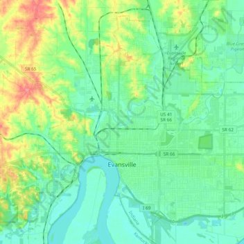
Nombre: Mapa topográfico Evansville, altitud, relieve.
Lugar: Evansville, Vanderburgh County, Indiana, United States (37.93559 -87.63755 38.05689 -87.44987)
Altitud media: 122 m
Altitud mínima: 105 m
Altitud máxima: 179 m
Otros mapas topográficos
Haga clic en un mapa para ver su topografía, su altitud y su relieve.
Inglefield
United States > Indiana > Vanderburgh County
Inglefield, Vanderburgh County, Indiana, 47725, United States
Altitud media: 142 m
Evansville
United States > Indiana > Vanderburgh County
Evansville, Vanderburgh County, Indiana, United States
Altitud media: 126 m
Smythe
United States > Indiana > Vanderburgh County > Evansville
Smythe, Evansville, Vanderburgh County, Indiana, 47715, United States
Altitud media: 119 m
Mud Center
United States > Indiana > Vanderburgh County > Evansville > Mud Center
Mud Center, Evansville, Vanderburgh County, Indiana, 47712, United States
Altitud media: 121 m
Saint Joseph
United States > Indiana > Vanderburgh County > Saint Joseph
Saint Joseph, Vanderburgh County, Indiana, 47720, United States
Altitud media: 156 m