
Mapa topográfico Drăgănești-Olt
Mapa interactivo
Haga clic en el mapa para ver la altitud.
Acerca de este mapa
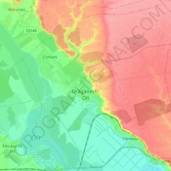
Nombre: Mapa topográfico Drăgănești-Olt, altitud, relieve.
Lugar: Drăgănești-Olt, Olt, Romania (44.12293 24.46656 44.22532 24.61533)
Altitud media: 101 m
Altitud mínima: 59 m
Altitud máxima: 148 m
The town is situated on the Wallachian Plain. It lies on the left bank of the river Olt, at an altitude of approximately 100 m (330 ft). It is located in the central part of Olt County, at a distance of 35 km (22 mi) from the county seat, Slatina, and 65 km (40 mi) north of Turnu Măgurele.
Otros mapas topográficos
Haga clic en un mapa para ver su topografía, su altitud y su relieve.