
Mapa topográfico Campsall
Mapa interactivo
Haga clic en el mapa para ver la altitud.
Acerca de este mapa
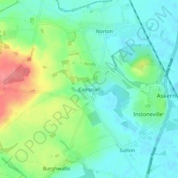
Nombre: Mapa topográfico Campsall, altitud, relieve.
Altitud media: 24 m
Altitud mínima: 3 m
Altitud máxima: 76 m
Campsall is a village and former civil parish, now in the parish of Norton, in the Doncaster district, in the county of South Yorkshire, England. It lies 7 miles (11 km) to the north-west of Doncaster, at an elevation of around 50 feet above sea level. The village contains Campsall Country Park. The village falls within the Norton & Askern ward of Doncaster Council and the House of Commons constituency of Doncaster North. The Parish is situated on the “Magnesian Limestone Belt”, a landscape feature formed by a narrow north–south trending escarpment. The Magnesian Limestone Belt is typified by well drained and fertile soils which were ideal for agriculture and the establishment of settlements like Campsall. Before the industrial revolution, the area to the east was occupied by the inaccessible and waterlogged marshes of the Humberhead Levels, whilst to the west was the Barnsdale Forest, an area associated with the legend of Robin Hood and various outlaws and bandits who preyed upon travellers on the Great North Road. In 1931 the parish had a population of 260.
Otros mapas topográficos
Haga clic en un mapa para ver su topografía, su altitud y su relieve.
Cusworth
United Kingdom > England > Doncaster
Cusworth, Doncaster, South Yorkshire, England, DN5 8UZ, United Kingdom
Altitud media: 25 m
Thorne
United Kingdom > England > Doncaster
Thorne, Doncaster, Yorkshire and the Humber, England, United Kingdom
Altitud media: 3 m
Fishlake
United Kingdom > England > Doncaster > Fishlake
Fishlake, Doncaster, South Yorkshire Mayoral Combined Authority, England, United Kingdom
Altitud media: 5 m