
Mapa topográfico Area F (Columbia Lake/Windermere Lake)
Mapa interactivo
Haga clic en el mapa para ver la altitud.
Acerca de este mapa
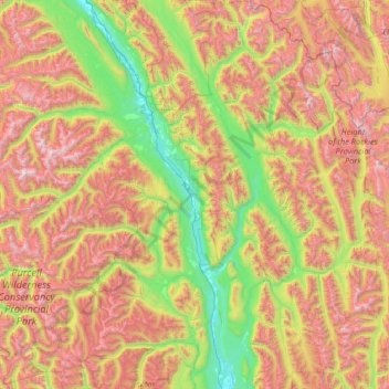
Nombre: Mapa topográfico Area F (Columbia Lake/Windermere Lake), altitud, relieve.
Altitud media: 1.815 m
Altitud mínima: 775 m
Altitud máxima: 3.425 m
Otros mapas topográficos
Haga clic en un mapa para ver su topografía, su altitud y su relieve.
Fairmont Hot Springs
Canada > British Columbia > Regional District of East Kootenay > Area F (Columbia Lake/Windermere Lake)
Fairmont Hot Springs, Area F (Columbia Lake/Windermere Lake), Regional District of East Kootenay, British Columbia, V0B 1L0, Canada
Altitud media: 920 m
Whiteswan Lake
Canada > British Columbia > Regional District of East Kootenay > Area F (Columbia Lake/Windermere Lake)
Whiteswan Lake, Area F (Columbia Lake/Windermere Lake), Regional District of East Kootenay, British Columbia, Canada
Altitud media: 1.392 m
Shuswap
Canada > British Columbia > Regional District of East Kootenay > Area F (Columbia Lake/Windermere Lake)
Shuswap, Area F (Columbia Lake/Windermere Lake), Regional District of East Kootenay, British Columbia, V0A 1K3, Canada
Altitud media: 926 m