
Mapa topográfico Andalo
Mapa interactivo
Haga clic en el mapa para ver la altitud.
Acerca de este mapa
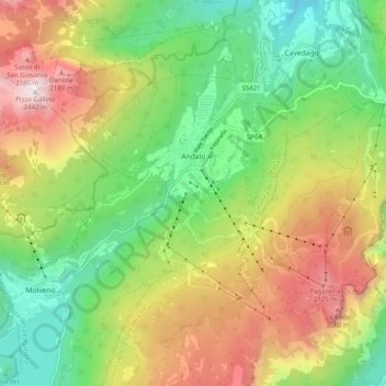
Nombre: Mapa topográfico Andalo, altitud, relieve.
Altitud media: 1.369 m
Altitud mínima: 655 m
Altitud máxima: 2.412 m
The town lies on the Paganella plateau, between the mountains Piz Galin, elevation 2,442 metres (8,012 ft), and Paganella, 2,125 metres (6,972 ft), and its territory is part of the Adamello-Brenta natural park.