
Mapa topográfico Ohio River
Mapa interactivo
Haga clic en el mapa para ver la altitud.
Acerca de este mapa
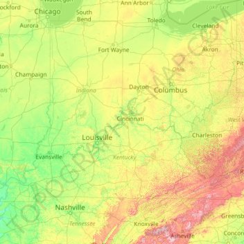
Nombre: Mapa topográfico Ohio River, altitud, relieve.
Lugar: Ohio River, United States (36.98350 -89.17727 40.69668 -80.01712)
Altitud media: 293 m
Altitud mínima: 79 m
Altitud máxima: 1.945 m
The river became a primary transportation route for pioneers during the westward expansion of the early U.S. The lower Ohio River just below Louisville was obstructed by rapids known as the Falls of the Ohio where the elevation falls 26 feet (7.9 m) in 2 miles (3.2 km) restricting larger commercial navigation, although in the 18th and early 19th century its three deepest channels could be traversed by a wide variety of craft then in use. In 1830, the Louisville and Portland Canal (now the McAlpine Locks and Dam) bypassed the rapids, allowing even larger commercial and modern navigation from the Forks of the Ohio at Pittsburgh to the Port of New Orleans at the mouth of the Mississippi on the Gulf of Mexico. Since the "canalization" of the river in 1929, the Ohio has not been a natural free-flowing river; today, it is divided into 21 discrete pools or reservoirs by 20 locks and dams for navigation and power generation.
Otros mapas topográficos
Haga clic en un mapa para ver su topografía, su altitud y su relieve.
Houston
United States > Texas > Harris County
Houston, Harris County, Texas, United States
Altitud media: 25 m
Bay Mills
United States > Michigan > Chippewa County
Bay Mills, Bay Mills Township, Chippewa County, Michigan, 49715, United States
Altitud media: 182 m
The Woodlands
United States > Texas > Montgomery County
The Woodlands, Montgomery County, Texas, United States
Altitud media: 47 m
Sequoia National Park
United States > California > Tulare County
Sequoia National Park, Tulare County, California, United States
Altitud media: 2.515 m
Sarasota
United States > Florida > Sarasota County
Sarasota, Sarasota County, Florida, United States
Altitud media: 7 m
Georgetown
United States > Texas > Georgetown
Georgetown, Williamson County, Texas, United States
Altitud media: 219 m
Fort Worth
United States > Texas > Tarrant County
Fort Worth, Tarrant County, Texas, United States
Altitud media: 212 m
Carmel
United States > Indiana > Hamilton County
Carmel, Hamilton County, Indiana, United States
Altitud media: 253 m
Central Park
United States > New York > New York County > New York
Central Park, New York County, New York, United States
Altitud media: 26 m
Queens County
United States > New York > New York
Queens County, New York, United States
Altitud media: 11 m
Hillsborough County
Hillsborough County, Florida, United States
Altitud media: 20 m
Safety Harbor
United States > Florida > Pinellas County
Safety Harbor, Pinellas County, Florida, 34695, United States
Altitud media: 11 m
Newton
United States > Massachusetts > Middlesex County
Newton, Middlesex County, Massachusetts, United States
Altitud media: 38 m
Morgantown
United States > West Virginia > Monongalia County
Morgantown, Monongalia County, West Virginia, United States
Altitud media: 337 m
Butler County
Butler County, Pennsylvania, United States
Altitud media: 376 m
Buncombe County
United States > North Carolina
Buncombe County, North Carolina, United States
Altitud media: 839 m
Arvada
United States > Colorado > Arvada
Arvada, Jefferson County, Colorado, United States
Altitud media: 1.796 m
Knoxville
United States > Tennessee > Knox County
Knoxville, Knox County, East Tennessee, Tennessee, United States
Altitud media: 307 m