
Mapa topográfico The Vly
Mapa interactivo
Haga clic en el mapa para ver la altitud.
Acerca de este mapa
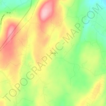
Nombre: Mapa topográfico The Vly, altitud, relieve.
Altitud media: 254 m
Altitud mínima: 160 m
Altitud máxima: 346 m
Otros mapas topográficos
Haga clic en un mapa para ver su topografía, su altitud y su relieve.
Mohonk Mountain House Property
United States > New York > Ulster County > Town of Marbletown
Mohonk Mountain House Property, Town of Marbletown, Town of Rochester, Ulster County, New York, United States
Altitud media: 228 m
Stone Ridge
United States > New York > Ulster County > Town of Marbletown
Stone Ridge, Town of Marbletown, Ulster County, New York, United States
Altitud media: 93 m
High Falls
United States > New York > Ulster County > Town of Marbletown
High Falls, Town of Marbletown, Ulster County, New York, United States
Altitud media: 77 m