
Mapa topográfico Hansford
Mapa interactivo
Haga clic en el mapa para ver la altitud.
Acerca de este mapa
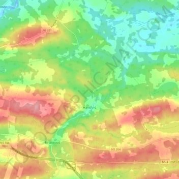
Nombre: Mapa topográfico Hansford, altitud, relieve.
Altitud media: 54 m
Altitud mínima: -4 m
Altitud máxima: 118 m
Otros mapas topográficos
Haga clic en un mapa para ver su topografía, su altitud y su relieve.
Hastings
Canada > Nova Scotia > Municipality of the County of Cumberland
Hastings, Municipality of the County of Cumberland, Cumberland County, Nova Scotia, B4H 3Y3, Canada
Altitud media: 63 m
Brookdale
Canada > Nova Scotia > Municipality of the County of Cumberland
Brookdale, Municipality of the County of Cumberland, Cumberland County, Nova Scotia, B4H 3Y3, Canada
Altitud media: 52 m
Southampton
Canada > Nova Scotia > Municipality of the County of Cumberland
Southampton, Municipality of the County of Cumberland, Cumberland County, Nova Scotia, B0M 1W0, Canada
Altitud media: 78 m
Port Philip
Canada > Nova Scotia > Municipality of the County of Cumberland
Port Philip, Municipality of the County of Cumberland, Cumberland County, Nova Scotia, B0K 1L0, Canada
Altitud media: 12 m
Muddy Plains
Canada > Nova Scotia > Municipality of the County of Cumberland > Shulie
Muddy Plains, Shulie, Municipality of the County of Cumberland, Cumberland County, Nova Scotia, B0L 1A0, Canada
Altitud media: 125 m