
Haz una donación
Equípate para tu próxima aventura:
Como asociado de Amazon, este sitio gana comisiones por las compras que califican, sin ningún costo adicional para usted.
Mapa topográfico Grenchen
Haga clic en el mapa para ver la altitud.
Haz una donación
Equípate para tu próxima aventura:
Como asociado de Amazon, este sitio gana comisiones por las compras que califican, sin ningún costo adicional para usted.
Grenchen
The municipality is the capital of the Lebern District. It is the second largest city in the Canton of Solothurn. The municipality stretches from the hamlet of Staad along the Aare river, (at an elevation of 430 m (1,410 ft)) to the first mountain range of the Jura Mountains (the Oberer Grenchenberg is 1,348 m (4,423 ft)).
Haz una donación
Equípate para tu próxima aventura:
Como asociado de Amazon, este sitio gana comisiones por las compras que califican, sin ningún costo adicional para usted.
Acerca de este mapa
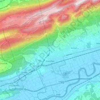
Nombre: Mapa topográfico Grenchen, altitud, relieve.
Altitud media: 705 m
Altitud mínima: 424 m
Altitud máxima: 1.411 m
Haz una donación
Equípate para tu próxima aventura:
Como asociado de Amazon, este sitio gana comisiones por las compras que califican, sin ningún costo adicional para usted.