
Mapa topográfico Greensboro
Mapa interactivo
Haga clic en el mapa para ver la altitud.
Acerca de este mapa
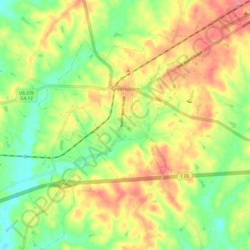
Nombre: Mapa topográfico Greensboro, altitud, relieve.
Lugar: Greensboro, Greene County, Georgia, United States (33.52492 -83.21894 33.60358 -83.13805)
Altitud media: 176 m
Altitud mínima: 137 m
Altitud máxima: 217 m
Otros mapas topográficos
Haga clic en un mapa para ver su topografía, su altitud y su relieve.
Lake Oconee
United States > Georgia > Greene County > Lake Oconee
Lake Oconee, Greene County, Georgia, United States
Altitud media: 165 m
White Plains
United States > Georgia > Greene County
White Plains, Greene County, Georgia, United States
Altitud media: 193 m