
Haz una donación
Equípate para tu próxima aventura:
Como asociado de Amazon, este sitio gana comisiones por las compras que califican, sin ningún costo adicional para usted.
Mapa topográfico Spartansburg
Haga clic en el mapa para ver la altitud.
Haz una donación
Equípate para tu próxima aventura:
Como asociado de Amazon, este sitio gana comisiones por las compras que califican, sin ningún costo adicional para usted.
Spartansburg
Spartansburg Borough is located on the glaciated plateau of northwestern Pennsylvania. The borough is drained by East Branch Oil Creek, which begins at the outlet of Clear Lake, an impoundment of Patrick Run and Stranahan Run. The lowest elevation in Spartansburg is 1,430 ft (440 m) where East Branch Oil Creek flows south out of the borough. The highest elevation is 1,640 ft (500 m) at the southeastern corner of the borough.
Haz una donación
Equípate para tu próxima aventura:
Como asociado de Amazon, este sitio gana comisiones por las compras que califican, sin ningún costo adicional para usted.
Acerca de este mapa
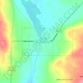
Nombre: Mapa topográfico Spartansburg, altitud, relieve.
Lugar: Spartansburg, Crawford County, Pennsylvania, United States (41.81954 -79.69392 41.82855 -79.67178)
Altitud media: 463 m
Altitud mínima: 428 m
Altitud máxima: 524 m
Haz una donación
Equípate para tu próxima aventura:
Como asociado de Amazon, este sitio gana comisiones por las compras que califican, sin ningún costo adicional para usted.