
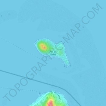
Mapa topográfico Petit St. Vincent
Mapa interactivo
Haga clic en el mapa para ver la altitud.
Acerca de este mapa
Nombre: Mapa topográfico Petit St. Vincent, altitud, relieve.
Altitud media: 2 m
Altitud mínima: 0 m
Altitud máxima: 90 m
Otros mapas topográficos
Haga clic en un mapa para ver su topografía, su altitud y su relieve.
Bequia
Saint Vincent and the Grenadines > Grenadines > Port Elizabeth
Bequia, Port Elizabeth, Grenadines, VC0400, Saint Vincent and the Grenadines
Altitud media: 16 m
Union Island
Saint Vincent and the Grenadines > Grenadines > Clifton
Union Island, Clifton, Grenadines, Saint Vincent and the Grenadines
Altitud media: 17 m
Lesser Antilles
Saint Vincent and the Grenadines
Lesser Antilles, Saint Vincent and the Grenadines
Altitud media: 1 m
Canouan
Saint Vincent and the Grenadines > Grenadines > Charlestown
Canouan, Charlestown, Grenadines, VC0450, Saint Vincent and the Grenadines
Altitud media: 14 m
Windward Islands
Saint Vincent and the Grenadines
Windward Islands, Saint Vincent and the Grenadines
Altitud media: 0 m
Big Sands
Saint Vincent and the Grenadines > Big Sands
Big Sands, Grenadines, VC0472, Saint Vincent and the Grenadines
Altitud media: 14 m
Saint David
Saint Vincent and the Grenadines
Saint David, Saint Vincent and the Grenadines
Altitud media: 306 m
Clare Valley
Saint Vincent and the Grenadines > Clare Valley
Clare Valley, Saint Andrew, Saint Vincent and the Grenadines
Altitud media: 55 m