
Mapa topográfico Valenzuela
Haga clic en el mapa para ver la altitud.
Valenzuela
The highest elevation point is 38 metres (125 ft) above sea level. Having a surface gradient of 0.55% and a gentle slope, hilly landscape is located in the industrial section of the city in Canumay. The average elevation point is 2 metres (6.6 ft) above sea level.
Acerca de este mapa
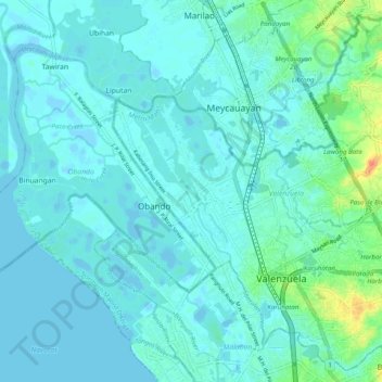
Nombre: Mapa topográfico Valenzuela, altitud, relieve.
Lugar: Valenzuela, Metro Manila, Philippines (14.66875 120.92579 14.75839 121.02459)
Altitud media: 6 m
Altitud mínima: -4 m
Altitud máxima: 40 m
Otros mapas topográficos
Haga clic en un mapa para ver su topografía, su altitud y su relieve.