
Mapa topográfico Newington
Mapa interactivo
Haga clic en el mapa para ver la altitud.
Acerca de este mapa
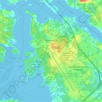
Nombre: Mapa topográfico Newington, altitud, relieve.
Lugar: Newington, Rockingham County, New Hampshire, United States (43.05903 -70.87996 43.12711 -70.78283)
Altitud media: 10 m
Altitud mínima: -7 m
Altitud máxima: 47 m
According to the United States Census Bureau, the town has a total area of 12.4 square miles (32.0 km2), of which 8.1 square miles (21.0 km2) are land and 4.2 square miles (11.0 km2) are water, comprising 34.5% of the town. The highest elevation in Newington is 130 feet (40 m) above sea level, near Newington Cemetery in the center of town.
Otros mapas topográficos
Haga clic en un mapa para ver su topografía, su altitud y su relieve.
Jenness Beach
United States > New Hampshire > Rockingham County > Rye > Rye Beach Village District
Jenness Beach, Rye Beach Village District, Rye, Rockingham County, New Hampshire, United States
Altitud media: 5 m
Northwood
United States > New Hampshire > Rockingham County
Northwood, Rockingham County, New Hampshire, 03261, United States
Altitud media: 167 m
Portsmouth
United States > New Hampshire > Rockingham County
Portsmouth, Rockingham County, New Hampshire, United States
Altitud media: 9 m
Stratham
United States > New Hampshire > Rockingham County
Stratham, Rockingham County, New Hampshire, 03885, United States
Altitud media: 22 m