
Haz una donación
Equípate para tu próxima aventura:
Como asociado de Amazon, este sitio gana comisiones por las compras que califican, sin ningún costo adicional para usted.
Mapa topográfico Pine Bluff
Haga clic en el mapa para ver la altitud.
Haz una donación
Equípate para tu próxima aventura:
Como asociado de Amazon, este sitio gana comisiones por las compras que califican, sin ningún costo adicional para usted.
Pine Bluff
The city is situated in the Southeast section of the Arkansas Delta and straddles the Arkansas Timberlands region to its west. Its topography is flat with wide expanses of farmland, similar to other places in the Delta Lowlands. Pine Bluff has numerous creeks, streams, and bayous, including Bayou Bartholomew, the longest bayou in the world and the second most ecologically diverse stream in the United States. Large bodies of water include Lake Pine Bluff, Lake Langhofer (Slack Water Harbor), and the Arkansas River.
Haz una donación
Equípate para tu próxima aventura:
Como asociado de Amazon, este sitio gana comisiones por las compras que califican, sin ningún costo adicional para usted.
Acerca de este mapa
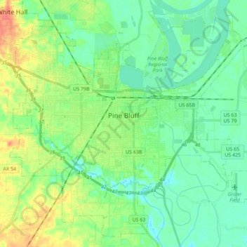
Nombre: Mapa topográfico Pine Bluff, altitud, relieve.
Lugar: Pine Bluff, Jefferson County, Arkansas, United States (34.14586 -92.09322 34.27595 -91.92123)
Altitud media: 69 m
Altitud mínima: 54 m
Altitud máxima: 100 m
Haz una donación
Equípate para tu próxima aventura:
Como asociado de Amazon, este sitio gana comisiones por las compras que califican, sin ningún costo adicional para usted.
Otros mapas topográficos
Haga clic en un mapa para ver su topografía, su altitud y su relieve.