
Mapa topográfico Yeager
Mapa interactivo
Haga clic en el mapa para ver la altitud.
Acerca de este mapa
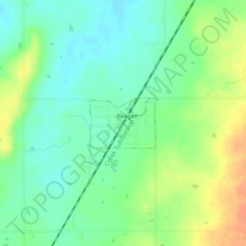
Nombre: Mapa topográfico Yeager, altitud, relieve.
Lugar: Yeager, Hughes County, Oklahoma, United States (35.15402 -96.34444 35.15957 -96.33567)
Altitud media: 245 m
Altitud mínima: 229 m
Altitud máxima: 268 m
The town lies at an elevation of 870 feet above sea level and has an average of 39 inches of rain and 6.1 inches of snowfall annually.
Otros mapas topográficos
Haga clic en un mapa para ver su topografía, su altitud y su relieve.
Calvin
United States > Oklahoma > Hughes County
Calvin, Hughes County, Oklahoma, 74531, United States
Altitud media: 232 m
Wetumka
United States > Oklahoma > Hughes County
Wetumka, Hughes County, Oklahoma, 74883, United States
Altitud media: 235 m
Atwood
United States > Oklahoma > Hughes County
Atwood, Hughes County, Oklahoma, United States
Altitud media: 243 m
Gerty
United States > Oklahoma > Hughes County
Gerty, Hughes County, Oklahoma, United States
Altitud media: 258 m
Spaulding
United States > Oklahoma > Hughes County
Spaulding, Hughes County, Oklahoma, United States
Altitud media: 251 m
Dustin
United States > Oklahoma > Hughes County
Dustin, Hughes County, Oklahoma, 74839, United States
Altitud media: 217 m
Horntown
United States > Oklahoma > Hughes County
Horntown, Hughes County, Oklahoma, United States
Altitud media: 255 m
Lamar
United States > Oklahoma > Hughes County
Lamar, Hughes County, Oklahoma, 74850, United States
Altitud media: 259 m
Stuart
United States > Oklahoma > Hughes County
Stuart, Hughes County, Oklahoma, United States
Altitud media: 229 m
Holdenville
United States > Oklahoma > Hughes County
Holdenville, Hughes County, Oklahoma, 74848, United States
Altitud media: 263 m