
Haz una donación
Equípate para tu próxima aventura:
Como asociado de Amazon, este sitio gana comisiones por las compras que califican, sin ningún costo adicional para usted.
Mapa topográfico Bijie
Haga clic en el mapa para ver la altitud.
Haz una donación
Equípate para tu próxima aventura:
Como asociado de Amazon, este sitio gana comisiones por las compras que califican, sin ningún costo adicional para usted.
Bijie
Bijie borders Zunyi to the east, Anshun and Liupanshui to the south, Zhaotong and Qujing (Yunnan) to the west, and Luzhou (Sichuan) to the north. It spans latitude 26°21′−27°46′ N and longitude 105°36′−106°43′ E, and is marked heavily by the presence of the Wumeng Mountains (乌蒙山) as well as karst topography. The Wu, Beipan, and Chishui Rivers are the most important rivers that originate here. The highest elevation is Jiucaiping (韭菜坪), at 2,900.6 m (9,516 ft), on the border of Hezhang and Weining counties.
Haz una donación
Equípate para tu próxima aventura:
Como asociado de Amazon, este sitio gana comisiones por las compras que califican, sin ningún costo adicional para usted.
Acerca de este mapa
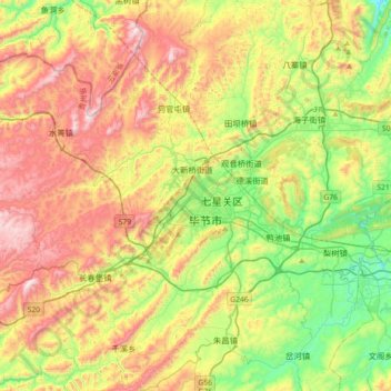
Nombre: Mapa topográfico Bijie, altitud, relieve.
Lugar: Bijie, Qixingguan, Bijie, Guizhou, 551700, China (27.12586 105.12660 27.44586 105.44660)
Altitud media: 1.651 m
Altitud mínima: 1.320 m
Altitud máxima: 2.158 m
Haz una donación
Equípate para tu próxima aventura:
Como asociado de Amazon, este sitio gana comisiones por las compras que califican, sin ningún costo adicional para usted.