
Mapa topográfico Gerlachovský štít
Mapa interactivo
Haga clic en el mapa para ver la altitud.
Acerca de este mapa
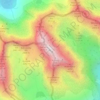
Nombre: Mapa topográfico Gerlachovský štít, altitud, relieve.
Altitud media: 2.103 m
Altitud mínima: 1.571 m
Altitud máxima: 2.618 m
Usually listed at 2655 metres AMSL (8,711 ft), its exact elevation is actually 0.6 metres (2.0 feet) lower. The pyramidal shape of the massif is marked by a huge cirque. Despite its relatively low elevation, the about 2,000 m vertical rise from the valley floor makes Gerlachovský štít soar. Mistaken for an average mountain in the rugged High Tatras range in the more distant past, it has since played a symbolic role in the eyes of the rulers and populations of several Central European nations, to the point that between the 19th and mid-20th century, it had four different names with six name reversals. It managed to be the highest mountain of the Kingdom of Hungary, and of the countries of Czechoslovakia, Slovakia and then Czechoslovakia again within the span of less than three decades of the 20th century.
Otros mapas topográficos
Haga clic en un mapa para ver su topografía, su altitud y su relieve.
Vysoké Tatry
Slovakia > Region of Prešov > District of Poprad > Vysoké Tatry > Vysoké Tatry
Vysoké Tatry, District of Poprad, Region of Prešov, Eastern Slovakia, 062 01, Slovakia
Altitud media: 1.107 m