
Haz una donación
Equípate para tu próxima aventura:
Como asociado de Amazon, este sitio gana comisiones por las compras que califican, sin ningún costo adicional para usted.
Mapa topográfico Buurhakaba
Haga clic en el mapa para ver la altitud.
Haz una donación
Equípate para tu próxima aventura:
Como asociado de Amazon, este sitio gana comisiones por las compras que califican, sin ningún costo adicional para usted.
Buurhakaba
Burhakaba is situated at the coordinates of 2.7991° N, 44.0794° E with an elevation of 196 meters above sea level. It lacks a permanent river, but it does have a large valley known as "Bohol Wiinti" that runs through the town from the north, east, and south-east. After seasonal rainfall, the valley supports farming in the area it drains. The annual rainfall in the town is estimated to be 550 to 620 mm (22 to 24 in). The town is primarily populated by the Eelaay clan, a sub-clan of Rahanweyn. The main language spoken in the town is Maay, the second largest dialect in Somalia.
Haz una donación
Equípate para tu próxima aventura:
Como asociado de Amazon, este sitio gana comisiones por las compras que califican, sin ningún costo adicional para usted.
Acerca de este mapa
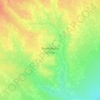
Nombre: Mapa topográfico Buurhakaba, altitud, relieve.
Lugar: Buurhakaba, Burhakaba District, Bay, South West, Somalia (2.63479 43.91845 2.95479 44.23845)
Altitud media: 203 m
Altitud mínima: 151 m
Altitud máxima: 306 m
Haz una donación
Equípate para tu próxima aventura:
Como asociado de Amazon, este sitio gana comisiones por las compras que califican, sin ningún costo adicional para usted.