
Haz una donación
Equípate para tu próxima aventura:
Como asociado de Amazon, este sitio gana comisiones por las compras que califican, sin ningún costo adicional para usted.
Mapa topográfico Duluth
Haga clic en el mapa para ver la altitud.
Haz una donación
Equípate para tu próxima aventura:
Como asociado de Amazon, este sitio gana comisiones por las compras que califican, sin ningún costo adicional para usted.
Duluth
Duluth's topography is distinctive, defined by its hilly terrain and its proximity to Lake Superior. The city is perched on an incline rising sharply from the lake, with elevations ranging from lake level at about 600 feet to approximately 1,400 feet at the ridge tops. This steep gradient creates dramatic natural overlooks, giving expansive views over the lake and the surrounding landscape. Duluth lies within the Arrowhead region of Minnesota, bordered by the ancient rock formations of the Superior Upland, remnants of volcanic activity and glacial sculpting. Additionally, its terrain includes numerous small rivers, valleys, and ridges that run toward the lake, adding to the area’s rugged appearance and making it a scenic but challenging landscape to navigate, particularly in winter conditions when snow and ice can make its sloping streets treacherous for travel.
Haz una donación
Equípate para tu próxima aventura:
Como asociado de Amazon, este sitio gana comisiones por las compras que califican, sin ningún costo adicional para usted.
Acerca de este mapa
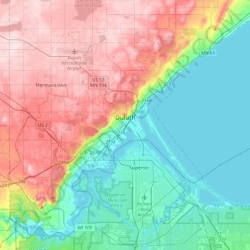
Nombre: Mapa topográfico Duluth, altitud, relieve.
Lugar: Duluth, Saint Louis County, Minnesota, United States (46.64916 -92.30124 46.88057 -91.92018)
Altitud media: 286 m
Altitud mínima: 178 m
Altitud máxima: 458 m
Haz una donación
Equípate para tu próxima aventura:
Como asociado de Amazon, este sitio gana comisiones por las compras que califican, sin ningún costo adicional para usted.
Otros mapas topográficos
Haga clic en un mapa para ver su topografía, su altitud y su relieve.
Haz una donación
Equípate para tu próxima aventura:
Como asociado de Amazon, este sitio gana comisiones por las compras que califican, sin ningún costo adicional para usted.
Haz una donación
Equípate para tu próxima aventura:
Como asociado de Amazon, este sitio gana comisiones por las compras que califican, sin ningún costo adicional para usted.
Haz una donación
Equípate para tu próxima aventura:
Como asociado de Amazon, este sitio gana comisiones por las compras que califican, sin ningún costo adicional para usted.
Haz una donación
Equípate para tu próxima aventura:
Como asociado de Amazon, este sitio gana comisiones por las compras que califican, sin ningún costo adicional para usted.
Haz una donación
Equípate para tu próxima aventura:
Como asociado de Amazon, este sitio gana comisiones por las compras que califican, sin ningún costo adicional para usted.