
Mapa topográfico Redfish Lake
Mapa interactivo
Haga clic en el mapa para ver la altitud.
Redfish Lake
The surface elevation of Redfish Lake is 6,547 feet (1,996 m) above sea level. The lake is 4.5 miles (7.2 km) long and 0.72 miles (1.2 km) wide, with a maximum depth of 387 feet (118 m), and 11 miles (18 km) of shoreline. The actual trail around the lake is 17.5 miles (28 km) in length.
Acerca de este mapa
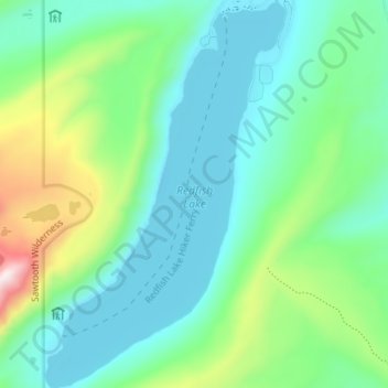
Nombre: Mapa topográfico Redfish Lake, altitud, relieve.
Lugar: Redfish Lake, Custer County, Idaho, United States (44.09323 -114.95587 44.14436 -114.91176)
Altitud media: 2.144 m
Altitud mínima: 1.989 m
Altitud máxima: 2.637 m
Otros mapas topográficos
Haga clic en un mapa para ver su topografía, su altitud y su relieve.
Stanley
United States > Idaho > Custer County
Stanley is located at 44°13′0″N 114°56′16″W / 44.21667°N 114.93778°W / 44.21667; -114.93778 (44.216698, -114.937814), at an elevation of 6,253 feet (1,906 m) above sea level
Altitud media: 1.931 m
Mackay
United States > Idaho > Custer County
Mackay is located at 43°54′43″N 113°36′49″W / 43.91194°N 113.61361°W / 43.91194; -113.61361 (43.911880, -113.613669), at an elevation of 5,905 feet (1,800 m).
Altitud media: 1.811 m
Challis
United States > Idaho > Custer County
Challis is located at 44°30′15″N 114°13′42″W / 44.50417°N 114.22833°W / 44.50417; -114.22833 (44.504260, -114.228279), at an elevation of 5,253 feet (1,601 m) above sea level.
Altitud media: 1.626 m