
Mapa topográfico Erkelenz
Mapa interactivo
Haga clic en el mapa para ver la altitud.
Erkelenz
Soon after its elevation to town status, work began on the brick fortifications of the place. These probably consisted of basic ramparts as had been common since time immemorial for the defence of settlements, which had been started in the 11th century. Although the castle was not documented until 1349, the town appeared to have developed under the protection of the castle along the Pangel, the oldest mentioned street (in deme Pandale, 1398) which was in its immediate vicinity. The nearby Johannismarkt (alder mart , Engl.: old market, 1420) and the more distant square known today simply as Markt ("market"), then referred to as the niewer mart (Engl.: new market, 1480), were also mentioned. In addition the castle had clearly been built within the town walls, so that it must have been there at least when town rights were granted in 1326. It is also hardly likely that an undefended place would have been elevated to the status of a town. Finally, the first and strongest town gateway, the Brück Gate (Brücktor, on Brückstraße) was built in 1355 on the Cologne Military Road (Kölner Heerbahn) that came from Roermond to Erkelenz and ran along the Theodor-Körner Road, Mühlenstraße and Wockerath to Cologne.
Acerca de este mapa
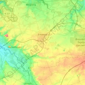
Nombre: Mapa topográfico Erkelenz, altitud, relieve.
Altitud media: 83 m
Altitud mínima: 42 m
Altitud máxima: 150 m
Otros mapas topográficos
Haga clic en un mapa para ver su topografía, su altitud y su relieve.
Auf dem Wengel
Germany > North Rhine-Westphalia > Kreis Heinsberg > Wegberg > Büch
Altitud media: 79 m
Hückelhoven
Germany > North Rhine-Westphalia > Kreis Heinsberg > Hückelhoven > Hückelhoven
Altitud media: 69 m