
Mapa topográfico Bärweiler
Mapa interactivo
Haga clic en el mapa para ver la altitud.
Acerca de este mapa
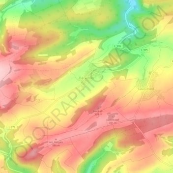
Nombre: Mapa topográfico Bärweiler, altitud, relieve.
Altitud media: 327 m
Altitud mínima: 208 m
Altitud máxima: 404 m
Bärweiler lies in picturesque hilly land between Bad Sobernheim and Meisenheim. The residential community characterized by agriculture has a municipal area measuring 611 ha. The municipality lies 10 km from Bad Sobernheim, 13 km from Kirn, 10 km from Meisenheim and roughly 30 km from the district seat, Bad Kreuznach. The village, which lies south of the Nahe, belongs to the northernmost part of the Saar-Nahe Uplands and Hills, more precisely to the Sien-Lauschied Ridge in the Meisenheim Uplands (Glan-Alsenz Mountains). Because of the lively breaking-up of the landscape into scattered, wooded hillocks and ridges, hollows and open plateau remnants, the countryside is also described as “humpy land”. The highest elevation in the municipality reaches 393.0 m above sea level, while the lowest point is 225.3 m above sea level.
Otros mapas topográficos
Haga clic en un mapa para ver su topografía, su altitud y su relieve.
Langenthal
Germany > Rhineland-Palatinate > Landkreis Bad Kreuznach
Langenthal, Nahe-Glan, Landkreis Bad Kreuznach, Rhineland-Palatinate, Germany
Altitud media: 319 m
Rüdesheim
Germany > Rhineland-Palatinate > Landkreis Bad Kreuznach
Rüdesheim, Landkreis Bad Kreuznach, Rhineland-Palatinate, 55593, Germany
Altitud media: 165 m
Rheingrafenstein
Germany > Rhineland-Palatinate > Landkreis Bad Kreuznach > Bad Kreuznach
Rheingrafenstein, Bad Kreuznach, Landkreis Bad Kreuznach, Rhineland-Palatinate, 55583, Germany
Altitud media: 218 m