
Haz una donación
Equípate para tu próxima aventura:
Como asociado de Amazon, este sitio gana comisiones por las compras que califican, sin ningún costo adicional para usted.
Mapa topográfico Welkom
Haga clic en el mapa para ver la altitud.
Haz una donación
Equípate para tu próxima aventura:
Como asociado de Amazon, este sitio gana comisiones por las compras que califican, sin ningún costo adicional para usted.
Welkom
Koppie Alleen is the only hill near Welkom and therefore is aptly named for its oddity. The terrain elevation above sea level is 1435 metres. The largest water catchment is the Sand River to the south-east of Welkom in Virginia's direction. Large saline pans such as Flamingo Pan and Theronia Pan are situated to the south-west of Welkom. Flamingo Pan is coded as an Important Bird Area (IBA)
Haz una donación
Equípate para tu próxima aventura:
Como asociado de Amazon, este sitio gana comisiones por las compras que califican, sin ningún costo adicional para usted.
Acerca de este mapa
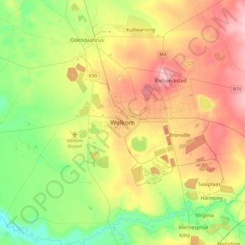
Nombre: Mapa topográfico Welkom, altitud, relieve.
Altitud media: 1.341 m
Altitud mínima: 1.271 m
Altitud máxima: 1.436 m
Haz una donación
Equípate para tu próxima aventura:
Como asociado de Amazon, este sitio gana comisiones por las compras que califican, sin ningún costo adicional para usted.
Otros mapas topográficos
Haga clic en un mapa para ver su topografía, su altitud y su relieve.
Bloemhof Dam
South Africa > Free State > Lejweleputswa District Municipality > Tswelopele Local Municipality
Altitud media: 1.251 m
Masilonyana Ward 3
South Africa > Free State > Lejweleputswa District Municipality > Masilonyana Local Municipality
Altitud media: 1.419 m
Tokologo Ward 3
South Africa > Free State > Lejweleputswa District Municipality > Tokologo Local Municipality
Altitud media: 1.214 m
Bloemhof Dam
South Africa > Free State > Lejweleputswa District Municipality > Tswelopele Local Municipality
Altitud media: 1.228 m
Haz una donación
Equípate para tu próxima aventura:
Como asociado de Amazon, este sitio gana comisiones por las compras que califican, sin ningún costo adicional para usted.
Tswelopele Ward 5
South Africa > Free State > Lejweleputswa District Municipality > Tswelopele Local Municipality
Altitud media: 1.295 m
Matjhabeng Local Municipality
South Africa > Free State > Lejweleputswa District Municipality
Altitud media: 1.376 m
HJ Joel Nature Reserve
South Africa > Free State > Lejweleputswa District Municipality > Masilonyana Local Municipality
Altitud media: 1.386 m
Haz una donación
Equípate para tu próxima aventura:
Como asociado de Amazon, este sitio gana comisiones por las compras que califican, sin ningún costo adicional para usted.
Erfenis Dam
South Africa > Free State > Lejweleputswa District Municipality > Masilonyana Local Municipality
Altitud media: 1.356 m
Tswelopele Local Municipality
South Africa > Free State > Lejweleputswa District Municipality
Altitud media: 1.294 m
Tokologo Ward 4
South Africa > Free State > Lejweleputswa District Municipality > Tokologo Local Municipality
Altitud media: 1.259 m
Tokologo Ward 2
South Africa > Free State > Lejweleputswa District Municipality > Tokologo Local Municipality
Altitud media: 1.255 m
Haz una donación
Equípate para tu próxima aventura:
Como asociado de Amazon, este sitio gana comisiones por las compras que califican, sin ningún costo adicional para usted.