
Haz una donación
Equípate para tu próxima aventura:
Como asociado de Amazon, este sitio gana comisiones por las compras que califican, sin ningún costo adicional para usted.
Mapa topográfico The Dalles
Haga clic en el mapa para ver la altitud.
Haz una donación
Equípate para tu próxima aventura:
Como asociado de Amazon, este sitio gana comisiones por las compras que califican, sin ningún costo adicional para usted.
The Dalles
As in the summer, winter temperatures can vary tremendously from one day to the next. During arctic air events the daytime high temperatures will generally be well below 32 °F or 0 °C, while a strong subtropical push can raise temperatures into the 50s and low 60s F, even in January. It is quite common for relatively cold air to become trapped at low elevations due to an inversion above; depending on the temperature of the surface airmass, depth of the inversion layer, and temperatures above the inversion layer, this can result in snow, sleet, freezing rain or a very cold liquid rain.
Haz una donación
Equípate para tu próxima aventura:
Como asociado de Amazon, este sitio gana comisiones por las compras que califican, sin ningún costo adicional para usted.
Acerca de este mapa
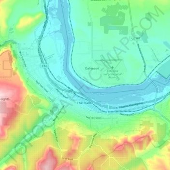
Nombre: Mapa topográfico The Dalles, altitud, relieve.
Lugar: The Dalles, Wasco County, Oregon, 97058, United States (45.58517 -121.22910 45.64030 -121.12104)
Altitud media: 105 m
Altitud mínima: 18 m
Altitud máxima: 343 m
Haz una donación
Equípate para tu próxima aventura:
Como asociado de Amazon, este sitio gana comisiones por las compras que califican, sin ningún costo adicional para usted.
Otros mapas topográficos
Haga clic en un mapa para ver su topografía, su altitud y su relieve.