
Mapa topográfico Yotei Zan
Mapa interactivo
Haga clic en el mapa para ver la altitud.
Acerca de este mapa
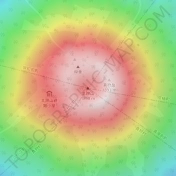
Nombre: Mapa topográfico Yotei Zan, altitud, relieve.
Altitud media: 1.372 m
Altitud mínima: 748 m
Altitud máxima: 1.881 m
In the 50,000:1 scale topographical map of the “Rusutsu” area published in 1920 by Japan’s Land Surveying Department, the mountain is recorded as "Shiribeshi-Yōtei-zan (Ezo-Fuji)". However, since the name was difficult to read, the town of Kutchan asked for it to be changed to Yōtei-zan. The change took place in the November 1969 topographical map published by the Geospatial Information Authority of Japan. Since then, the current name of Yōtei-zan has become established.