
Mapa topográfico Pegnitz
Mapa interactivo
Haga clic en el mapa para ver la altitud.
Acerca de este mapa
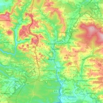
Nombre: Mapa topográfico Pegnitz, altitud, relieve.
Lugar: Pegnitz, Landkreis Bayreuth, Bavaria, 91257, Germany (49.69628 11.42391 49.83802 11.63376)
Altitud media: 485 m
Altitud mínima: 392 m
Altitud máxima: 637 m
Otros mapas topográficos
Haga clic en un mapa para ver su topografía, su altitud y su relieve.
95469
Germany > Bavaria > Landkreis Bayreuth > Kirchenlaibach
95469, Kirchenlaibach, Speichersdorf, Landkreis Bayreuth, Bavaria, Germany
Altitud media: 464 m
Waischenfeld
Germany > Bavaria > Landkreis Bayreuth
Waischenfeld, Landkreis Bayreuth, Bavaria, 91344, Germany
Altitud media: 435 m
Görschnitz
Germany > Bavaria > Landkreis Bayreuth > Weidenberg
Görschnitz, Weidenberg, Weidenberg (VGem), Landkreis Bayreuth, Bavaria, 95466, Germany
Altitud media: 486 m
Gefrees
Germany > Bavaria > Landkreis Bayreuth
Gefrees, Landkreis Bayreuth, Bavaria, 95482, Germany
Altitud media: 585 m