
Haz una donación
Equípate para tu próxima aventura:
Como asociado de Amazon, este sitio gana comisiones por las compras que califican, sin ningún costo adicional para usted.
Mapa topográfico Mount Bromo
Haga clic en el mapa para ver la altitud.
Haz una donación
Equípate para tu próxima aventura:
Como asociado de Amazon, este sitio gana comisiones por las compras que califican, sin ningún costo adicional para usted.
Acerca de este mapa
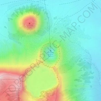
Nombre: Mapa topográfico Mount Bromo, altitud, relieve.
Lugar: Mount Bromo, Pasuruan, Indonesia (-7.94212 112.95293 -7.94202 112.95303)
Altitud media: 2.239 m
Altitud mínima: 2.110 m
Altitud máxima: 2.504 m
Haz una donación
Equípate para tu próxima aventura:
Como asociado de Amazon, este sitio gana comisiones por las compras que califican, sin ningún costo adicional para usted.
Otros mapas topográficos
Haga clic en un mapa para ver su topografía, su altitud y su relieve.
Pulau Bali
Bali features a diverse topography shaped by a volcanic origin, which significantly influences its landscapes and climate. The island is dominated by a central mountain range that runs from west to east, with Mount Agung, reaching an elevation of approximately 10,308 feet, standing as the highest peak and a…
Altitud media: 122 m
Special Capital Region of Jakarta
Jakarta lies in a low and flat alluvial plain, ranging from −2 to 91 m (−7 to 299 ft) with an average elevation of 8 m (26 ft) above sea level with historically extensive swampy areas. Some parts of the city have been constructed on reclaimed tidal flats that occur in around the area. Thirteen rivers flow…
Altitud media: 5 m
Haz una donación
Equípate para tu próxima aventura:
Como asociado de Amazon, este sitio gana comisiones por las compras que califican, sin ningún costo adicional para usted.
Java
Java is an island with a large amount of biodiversity. The natural environment of Java is tropical rainforest, with ecosystems ranging from coastal mangrove forest on the north coast, rocky coastal cliffs on the southern coast, and low-lying tropical forest to high altitude rainforest on the slopes of…
Altitud media: 39 m
Haz una donación
Equípate para tu próxima aventura:
Como asociado de Amazon, este sitio gana comisiones por las compras que califican, sin ningún costo adicional para usted.
Pecatu
Indonesia > Bali > Kuta Selatan
Pecatu is located in South Kuta District of Badung Regency. It is at the western end of the Bukit Peninsula in south Bali, and has a hilly topography with limestone cliffs isolating small, short beaches that have been privately developed. Nusa Dua, on the opposite side of the peninsula, is flat and is a…
Altitud media: 64 m
Lombok
Indonesia > West Nusa Tenggara
The island's topography is dominated by the centrally-located stratovolcano Mount Rinjani, the second-highest volcano in Indonesia, which rises to 3,726 metres (12,224 ft), making Lombok the 8th-highest island. The most recent eruption of Rinjani occurred in September 2016 at Gunung Barujari. In a 2010…
Altitud media: 192 m
Haz una donación
Equípate para tu próxima aventura:
Como asociado de Amazon, este sitio gana comisiones por las compras que califican, sin ningún costo adicional para usted.
Haz una donación
Equípate para tu próxima aventura:
Como asociado de Amazon, este sitio gana comisiones por las compras que califican, sin ningún costo adicional para usted.
East Java
East Java has a tropical monsoon and savanna climate at lower elevation and subtropical at higher elevation. Compared with the western part of Java Island, East Java in general has less rainfall. Average rainfall is 1,900 mm per year, with a rainy season during the 100 days. The average temperature ranges…
Altitud media: 62 m
Bali
Bali's central mountains include several peaks over 2,000 metres (6,600 feet) in elevation and active volcanoes such as Mount Batur. The highest is Mount Agung (3,031 m, 9,944 ft), known as the "mother mountain", which is an active volcano rated as one of the world's most likely sites for a massive eruption…
Altitud media: 88 m
Bandung City
Bandung (Sundanese: ᮘᮔ᮪ᮓᮥᮀ, romanized: Bandung, Sundanese pronunciation: [ˈbandʊŋ]; /ˈbɑːndʊŋ/) is the capital city of the Indonesian province of West Java. It has a population of 2,452,943 within its city limits according to the official estimates as at mid 2021, making it the fourth most…
Altitud media: 830 m
Haz una donación
Equípate para tu próxima aventura:
Como asociado de Amazon, este sitio gana comisiones por las compras que califican, sin ningún costo adicional para usted.
Bekasi
The City of Bekasi is a part of the Bekasi river basin, located in the downstream area of the basin with slopes ranging from 0 to 2% and elevations between 11 meters to 81 meters above sea level. The city of Bekasi is part of the Bekasi river basin and is located in the downstream area of the basin, with a…
Altitud media: 32 m
Semarang
Semarang is located on the northern coast of Java. The city of Semarang is one of the important cities located on the north coast of Java and as the main hub connecting Jakarta and Surabaya, and cities in the southern interior of Java Surakarta and Yogyakarta. Semarang City has a height ranging from 2 m (6.6…
Altitud media: 107 m
Haz una donación
Equípate para tu próxima aventura:
Como asociado de Amazon, este sitio gana comisiones por las compras que califican, sin ningún costo adicional para usted.
Temanggung
Temanggung Regency is located on the volcanic Dieng Plateau with an average elevation between 500 and 1450 meters. It is landlocked. The volcanoes Mount Sundoro and Mount Sumbing rise on its border with the Wonosobo Regency. Its major drainage system is the Progo River and its tributaries.
Altitud media: 771 m
North Sumatra
Half of the province is located on a high plateau that runs along the Bukit Barisan mountains, from central North Sumatra to the western coast. The tallest mountain in the province is Mount Sinabung in Karo Regency, at elevation around 2,460 metres (8,070 ft), the most active volcano in the region. Volcanic…
Altitud media: 200 m
Haz una donación
Equípate para tu próxima aventura:
Como asociado de Amazon, este sitio gana comisiones por las compras que califican, sin ningún costo adicional para usted.
Tangerang
Topographically, Tangerang City is mostly located at an altitude of 10-30 meters above sea level, aka the whole area is in the lowlands. The northern part of the city (covering most of Benda District) has an average height of 10 meters above sea level, while the southern part of Tangerang City has a height of…
Altitud media: 16 m
Borneo
Before sea levels rose at the end of the last ice age, Borneo was part of the mainland of Asia, forming, with Java and Sumatra, the upland regions of a peninsula that extended east from present day Indochina. The South China Sea and Gulf of Thailand now submerge the former low-lying areas of the peninsula.…
Altitud media: 141 m
Haz una donación
Equípate para tu próxima aventura:
Como asociado de Amazon, este sitio gana comisiones por las compras que califican, sin ningún costo adicional para usted.
Haz una donación
Equípate para tu próxima aventura:
Como asociado de Amazon, este sitio gana comisiones por las compras que califican, sin ningún costo adicional para usted.
Haz una donación
Equípate para tu próxima aventura:
Como asociado de Amazon, este sitio gana comisiones por las compras que califican, sin ningún costo adicional para usted.
Borneo
Before sea levels rose at the end of the last Ice Age, Borneo was part of the mainland of Asia, forming, with Java and Sumatra, the upland regions of a peninsula that extended east from present day Indochina. The South China Sea and Gulf of Thailand now submerge the former low-lying areas of the peninsula.…
Altitud media: 141 m
Haz una donación
Equípate para tu próxima aventura:
Como asociado de Amazon, este sitio gana comisiones por las compras que califican, sin ningún costo adicional para usted.
Haz una donación
Equípate para tu próxima aventura:
Como asociado de Amazon, este sitio gana comisiones por las compras que califican, sin ningún costo adicional para usted.
West Papua
West Papua is located between 0–4 degrees South Latitude and 124–132 degrees East Longitude, just below the equator with an altitude of 0–100 m (0–328 ft) above sea level. The area of West Papua before the creation of Southwest Papua Province was 99,398.26 km2 (38,377.88 sq mi), and is currently about…
Altitud media: 135 m
Haz una donación
Equípate para tu próxima aventura:
Como asociado de Amazon, este sitio gana comisiones por las compras que califican, sin ningún costo adicional para usted.
Central Java
The Southern Serayu Mountains are part of the South Central Java Basin located in the southern part of the province. This mandala is a geoantiklin that extends from west to east along 100 kilometres and is divided into two parts separated by the Jatilawang valley, namely the western and eastern regions. The…
Altitud media: 83 m
Haz una donación
Equípate para tu próxima aventura:
Como asociado de Amazon, este sitio gana comisiones por las compras que califican, sin ningún costo adicional para usted.
Haz una donación
Equípate para tu próxima aventura:
Como asociado de Amazon, este sitio gana comisiones por las compras que califican, sin ningún costo adicional para usted.
Haz una donación
Equípate para tu próxima aventura:
Como asociado de Amazon, este sitio gana comisiones por las compras que califican, sin ningún costo adicional para usted.
Haz una donación
Equípate para tu próxima aventura:
Como asociado de Amazon, este sitio gana comisiones por las compras que califican, sin ningún costo adicional para usted.
Denpasar
Denpasar is located at an elevation of 4 m (13 ft) above sea level. While the total area of 125.98 km2 or 2.18% of the total area of Bali Province. From the use of land, 2,768 hectares of land are paddy, 10,001 hectares are dry land, while the remaining land area is 9 hectares.
Altitud media: 7 m
Haz una donación
Equípate para tu próxima aventura:
Como asociado de Amazon, este sitio gana comisiones por las compras que califican, sin ningún costo adicional para usted.
Haz una donación
Equípate para tu próxima aventura:
Como asociado de Amazon, este sitio gana comisiones por las compras que califican, sin ningún costo adicional para usted.
Denpasar
Denpasar is located at an elevation of 4 m (13 ft) above sea level. While the total area of 125.98 km2 or 2.18% of the total area of Bali Province. From the use of land, 2,768 hectares of land are paddy, 10,001 hectares are dry land, while the remaining land area is 9 hectares.
Altitud media: 7 m
Haz una donación
Equípate para tu próxima aventura:
Como asociado de Amazon, este sitio gana comisiones por las compras que califican, sin ningún costo adicional para usted.
Sanggau
Sanggau Regency borders Sintang and Sekadau Regencies in the east, Malaysia in the north, Ketapang Regency in the south, and Landak Regency in the west. Sanggau Regency is located in the interior of Borneo, and is divided by the Kapuas River, which is one of the longest rivers in Indonesia. Its topography is…
Altitud media: 106 m
Haz una donación
Equípate para tu próxima aventura:
Como asociado de Amazon, este sitio gana comisiones por las compras que califican, sin ningún costo adicional para usted.
North Sulawesi
The province's capital and largest city is Manado, which is also the main gateway and the economic center of the province. Other major towns includes Tomohon and Bitung in the northern (Minahasa) half of the province, and Kotamobagu in the southern (Bolaang Mongondow) half. There are 41 mountains with an…
Altitud media: 28 m
Haz una donación
Equípate para tu próxima aventura:
Como asociado de Amazon, este sitio gana comisiones por las compras que califican, sin ningún costo adicional para usted.
Borneo
Before sea levels rose at the end of the last ice age, Borneo was part of the mainland of Asia, forming, with Java and Sumatra, the upland regions of a peninsula that extended east from present day Indochina. The South China Sea and Gulf of Thailand now submerge the former low-lying areas of the peninsula.…
Altitud media: 141 m
Haz una donación
Equípate para tu próxima aventura:
Como asociado de Amazon, este sitio gana comisiones por las compras que califican, sin ningún costo adicional para usted.
Haz una donación
Equípate para tu próxima aventura:
Como asociado de Amazon, este sitio gana comisiones por las compras que califican, sin ningún costo adicional para usted.
Java
Java is an island with a large amount of biodiversity. The natural environment of Java is tropical rainforest, with ecosystems ranging from coastal mangrove forest on the north coast, rocky coastal cliffs on the southern coast, and low-lying tropical forest to high altitude rainforest on the slopes of…
Altitud media: 39 m
Sulawesi
The lowland forests on the island have mostly been removed. Because of the relative geological youth of the island and its dramatic and sharp topography, the lowland areas are naturally limited in their extent. The past decade has seen dramatic conversion of this rare and endangered habitat. The island also…
Altitud media: 95 m
Haz una donación
Equípate para tu próxima aventura:
Como asociado de Amazon, este sitio gana comisiones por las compras que califican, sin ningún costo adicional para usted.