
Mapa topográfico Sonamarg
Mapa interactivo
Haga clic en el mapa para ver la altitud.
Acerca de este mapa
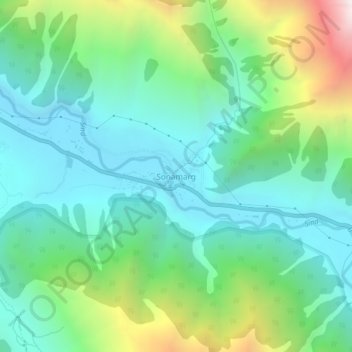
Nombre: Mapa topográfico Sonamarg, altitud, relieve.
Lugar: Sonamarg, Kangan, Ganderbal district, Jammu and Kashmir, India (34.28239 75.27656 34.32239 75.31656)
Altitud media: 3.068 m
Altitud mínima: 2.639 m
Altitud máxima: 4.240 m
The hill station is situated in the Kashmir Valley, at an altitude of 2,730 metres (8,960 ft) and is close to some of the valley's tallest peaks, alongside the Machoi Glacier, Sirbal Peak, Kolahoi Peak, Amarnath Peak and Machoi Peak. Combined with the alpine meadows that bloom in the summer as well as rivers and lakes stocked with fish, Sonamarg is a notable tourist destination in Jammu and Kashmir.
Otros mapas topográficos
Haga clic en un mapa para ver su topografía, su altitud y su relieve.
Gagangir
India > Jammu and Kashmir > Kangan
Gagangir, Kangan, Ganderbal district, Jammu and Kashmir, India
Altitud media: 2.795 m
Kangan
India > Jammu and Kashmir > Kangan
Kangan, Ganderbal District, Jammu and Kashmir, India
Altitud media: 3.335 m