
Mapa topográfico Lake Lanao
Mapa interactivo
Haga clic en el mapa para ver la altitud.
Acerca de este mapa
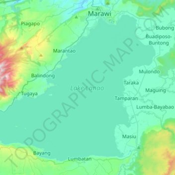
Nombre: Mapa topográfico Lake Lanao, altitud, relieve.
Lugar: Lake Lanao, Lanao del Sur, Bangsamoro, Philippines (7.78083 124.10453 8.00328 124.37106)
Altitud media: 787 m
Altitud mínima: 614 m
Altitud máxima: 1.798 m
The lake has great hydroelectric potential due to its 700 meter elevation, and as such, in 1950, the Philippines National Power Corporation (NAPOCOR) began the construction of a series of hydroelectric plants titled Agus I – Agus VII along the Agus River system, which generates 70% of the electricity used by the people of Mindanao. In 1978, the Marawi Lake Regulation Dam (MLRD) was constructed at the mouth of the Agus, and five power plants were commissioned shortly afterwards (Agus I, II, IV, V, and VII). Notably, Agus I is not located on the river, but directly on the shoreline of the lake, in the heart of Marawi City. While the MLRD does not affect the function of the four downstream dams, the construction of Agus I effectively turned the lake into a reservoir, sparking significant backlash among the Maranao. In October 1990, the Maranao publicly demonstrated as Agus I was finishing construction, leading to the birth of the Save Lake Lanao Movement (SALAM), which intended to obstruct NAPOCOR's progress in building Agus I. SALAM contended that the dam would act as an artificial, alternative outlet to the Agus that is deeply unnatural and would result in a 9 meter fluctuation of the lake level. Conflict between SALAM and NAPOCOR resulted in the creation of the Task Force on Agus 1 by Aquilino Pimentel Jr., which subsequently delayed the commission date of the plant to January 14, 1992. In the two months following Agus I's operation date, President Corazon Aquino declared the Lake Lanao watershed as a reservation and established the Lake Lanao Watershed Protection and Development Council (LLWPDC), a policy group with both SALAM and NAPOCOR representatives. Despite these efforts, NAPOCOR has since not made any major concessions to the Maranao. SALAM and the Maranao continue to protect the Lanao watershed from environmental degradation.
Otros mapas topográficos
Haga clic en un mapa para ver su topografía, su altitud y su relieve.
Balindong
Balindong, Lanao del Sur, Bangsamoro, 9318, Philippines
Altitud media: 822 m
Balabagan
Balabagan, Lanao del Sur, Bangsamoro, Philippines
Altitud media: 47 m
Ditsaan-Ramain
Ditsaan-Ramain, Lanao del Sur, Bangsamoro, Philippines
Altitud media: 699 m
Amai Manabilang
Amai Manabilang, Lanao del Sur, Bangsamoro, Philippines
Altitud media: 969 m
Mount Ragang
Mount Ragang, Lanao del Sur, Bangsamoro, Philippines
Altitud media: 2.282 m
Marawi
Marawi, Lanao del Sur, Bangsamoro, 9700, Philippines
Altitud media: 707 m
Saguiaran
Philippines > Lanao del Sur > Saguiaran
Saguiaran, Lanao del Sur, Bangsamoro Autonomous Region in Muslim Mindanao, 09700, Philippines
Altitud media: 662 m
Agus River
Philippines > Lanao del Sur > Marawi
Agus River, Marawi, Lanao del Sur, Bangsamoro, Philippines
Altitud media: 569 m
Sacred Mountain National Park
Philippines > Lanao del Sur > Marawi
Sacred Mountain National Park, Marawi-Kapa-i Road, Marawi, Lanao del Sur, BARMM, 9700, Philippines
Altitud media: 710 m
Lake Butig
Philippines > Lanao del Sur > Pindolonan
Lake Butig, Pindolonan, Lanao del Sur, Bangsamoro, Philippines
Altitud media: 777 m
Mount Maranat
Philippines > Lanao del Sur > Marawi
Mount Maranat, Marawi, Lanao del Sur, Bangsamoro, Philippines
Altitud media: 1.620 m
Makaturing
Makaturing, Lanao del Sur, Bangsamoro, Philippines
Altitud media: 1.555 m
Mount Cabugao
Philippines > Lanao del Sur > Marawi
Mount Cabugao, Marawi, Lanao del Sur, BARMM, Philippines
Altitud media: 541 m