
Mapa topográfico Red Hill
Mapa interactivo
Haga clic en el mapa para ver la altitud.
Acerca de este mapa
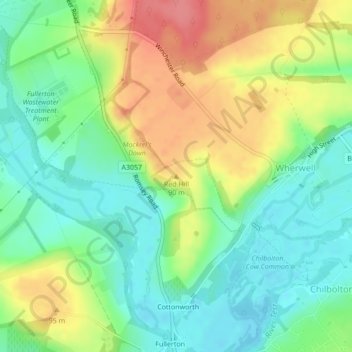
Nombre: Mapa topográfico Red Hill, altitud, relieve.
Altitud media: 69 m
Altitud mínima: 38 m
Altitud máxima: 114 m
Otros mapas topográficos
Haga clic en un mapa para ver su topografía, su altitud y su relieve.
Palestine
United Kingdom > England > Hampshire > Test Valley
Palestine, Over Wallop, Test Valley, Hampshire, England, SP11 7EW, United Kingdom
Altitud media: 109 m