
Mapa topográfico Ljubljana
Mapa interactivo
Haga clic en el mapa para ver la altitud.
Acerca de este mapa
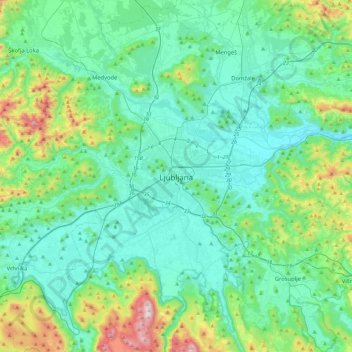
Nombre: Mapa topográfico Ljubljana, altitud, relieve.
Lugar: Ljubljana, Upravna Enota Ljubljana, 1000, Slovenia (45.88998 14.34686 46.20998 14.66686)
Altitud media: 412 m
Altitud mínima: 251 m
Altitud máxima: 1.094 m
Ljubljana has an elevation of 295 meters (968 ft) The city centre, located along the Ljubljanica River, has an elevation of 298 meters (978 ft). Ljubljana Castle, which sits atop Castle Hill (Grajski grič) south of the city centre, has an elevation of 366 meters (1,201 ft). The highest point of the city, called Grmada, reaches 676 meters (2,218 ft), 3 meters (9.8 ft) more than the nearby Mount Saint Mary (Šmarna gora) peak, a popular hiking destination. These are located in the northern part of the city.
Otros mapas topográficos
Haga clic en un mapa para ver su topografía, su altitud y su relieve.