
Mapa topográfico Camels Hump
Mapa interactivo
Haga clic en el mapa para ver la altitud.
Acerca de este mapa
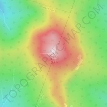
Nombre: Mapa topográfico Camels Hump, altitud, relieve.
Altitud media: 843 m
Altitud mínima: 534 m
Altitud máxima: 1.223 m
The summit of Camel's Hump is home to 10 acres (4 ha) of alpine tundra vegetation. Common plants found in this area include: Bigelow's sedge (Carex bigelowii), alpine bilberry (Vaccinium uliginosum), mountain sandwort (Minuartia groenlandica), crowberry (Empetrum nigrum), mountain cranberry (Vaccinium vitis-idaea), and Labrador tea (Rhododendron groenlandicum). A direct result of glacial formation, these alpine species were once widespread but as the lower elevations warmed, only the very peak of Camel's Hump remained hospitable to the fragile plants.
Otros mapas topográficos
Haga clic en un mapa para ver su topografía, su altitud y su relieve.
Hanksville
United States > Vermont > Chittenden County > Huntington
Hanksville, Huntington, Chittenden County, Vermont, United States
Altitud media: 426 m