
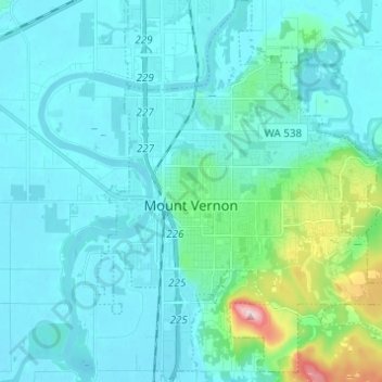
Mapa topográfico Mount Vernon
Mapa interactivo
Haga clic en el mapa para ver la altitud.
Acerca de este mapa
Nombre: Mapa topográfico Mount Vernon, altitud, relieve.
Altitud media: 37 m
Altitud mínima: 0 m
Altitud máxima: 288 m
Otros mapas topográficos
Haga clic en un mapa para ver su topografía, su altitud y su relieve.
Mount Erie
United States > Washington > Skagit County > Anacortes
Mount Erie, Anacortes, Skagit County, Washington, 98221, United States
Altitud media: 128 m
Marblemount
United States > Washington > Skagit County
Marblemount, Skagit County, Washington, United States
Altitud media: 249 m
Big Lake
United States > Washington > Skagit County
Big Lake, Skagit County, Washington, 98274, United States
Altitud media: 80 m
Anacortes
United States > Washington > Skagit County
Anacortes, Skagit County, Washington, 98221, United States
Altitud media: 36 m
Anacortes
United States > Washington > Skagit County > Anacortes > Anacortes
Anacortes, Skagit County, Washington, 98221, United States
Altitud media: 37 m
Concrete
United States > Washington > Skagit County
Concrete, Skagit County, Washington, United States
Altitud media: 125 m
Coal Mountain
United States > Washington > Skagit County
Coal Mountain, Skagit County, Washington, United States
Altitud media: 1.003 m
Sedro-Woolley
United States > Washington > Skagit County
Sedro-Woolley, Skagit County, Washington, United States
Altitud media: 28 m
Burlington
United States > Washington > Skagit County
Burlington, Skagit County, Washington, 98233, United States
Altitud media: 12 m