
Mapa topográfico Shahin Shahr
Mapa interactivo
Haga clic en el mapa para ver la altitud.
Acerca de este mapa
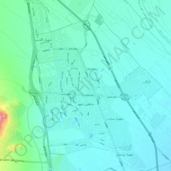
Nombre: Mapa topográfico Shahin Shahr, altitud, relieve.
Altitud media: 1.601 m
Altitud mínima: 1.583 m
Altitud máxima: 1.709 m
Otros mapas topográficos
Haga clic en un mapa para ver su topografía, su altitud y su relieve.
دهستان برخوار غربی
Iran > Isfahan Province > Shahin Shahr and Meymeh County
دهستان برخوار غربی, Shahin Shahr and Meymeh Central District, Shahin Shahr and Meymeh County, Isfahan Province, Iran
Altitud media: 1.806 m