Geolocalizar

Mapa topográfico Luzon

Haga clic en el mapa para ver la altitud.

Acerca de este mapa

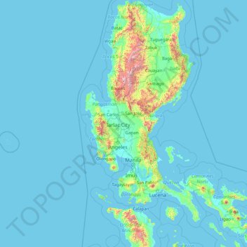
Nombre: Mapa topográfico Luzon, altitud, relieve.

Lugar: Luzon, Central Luzon, Philippines (12.53287 119.74983 18.65129 124.19838)

Altitud media: 88 m

Altitud mínima: -1 m

Altitud máxima: 2.758 m

Otros mapas topográficos

Haga clic en un mapa para ver su topografía, su altitud y su relieve.

Quezon City

Philippines

Founded as a pueblo by Saint Pedro Bautista in 1590, San Francisco del Monte may be considered Quezon City's oldest district. The original land area of the old town of San Francisco del Monte was approximately2.5 square kilometres (1.0 sq mi) and covered parts of what is currently known as Project 7 and 8 and…

Altitud media: 57 m

Cebu City

Philippines > Cebu > Cebu City

Altitud media: 140 m

Butuan

Philippines

Altitud media: 115 m

Calamba

Philippines > Laguna

Altitud media: 100 m

Bacolod

Philippines

Bacólod (English: Bacolod), is derived from bakólod (Old Spelling: bacólod), the Old Hiligaynon (Old Ilonggo) (Old Spelling: Ylongo and Ilongo) word for a "hill, turtle, mound, rise, hillock, down, any small eminence or elevation", since the resettlement was founded on a stony, hilly area, now the barangay…

Altitud media: 49 m

Labo

Philippines > Camarines Norte

Altitud media: 30 m

Valencia

Philippines > Bukidnon

The city's topography is characterized as flat to undulating hills with extensive plateaus and mountainous areas and cliffs on both eastern and western portions bounding the municipality of San Fernando on the east and the municipality of Talakag on the west. Its highest point is Mount Kalatungan in the…

Altitud media: 566 m

Malolos

Philippines > Bulacan

Malolos is relatively flat of about 0.81% to a gently sloping of 2.17%. The slope of the land descends towards west, southwest to southern direction. The highest land elevation is at about 6.0 meters above sea level while the lowest is only half a meter below sea level. A network of natural waterways and…

Altitud media: 6 m

Iligan

Philippines

Altitud media: 229 m

San Fernando

Philippines > La Union

Altitud media: 81 m

Mandaue

Philippines

It is one of the two (the other one being the municipality of Consolacion) local government units located within the mainland Metro Cebu where the elevation of land is less than 100 m (330 ft).

Altitud media: 109 m

Baguio

Philippines

In 1903, Filipinos, Japanese and Chinese workers were hired to build Kennon Road, the first road directly connecting Baguio with the lowlands of La Union and Pangasinan. Before this, the only road to Benguet was Naguilian Road, and it was largely a horse trail at higher elevations. Camp John Hay was…

Altitud media: 881 m

Meycauayan

Philippines > Bulacan

Altitud media: 27 m

Legazpi

Philippines > Albay

Legazpi's topography is generally plain on the northeastern areas, with slopes ranging from five to fifteen degrees. The southern areas have mostly rolling to hilly terrain. In the city's coastal areas, the terrain varies from plain (north) to hilly (south). Legazpi is criss-crossed by several rivers including…

Altitud media: 150 m

San Juan

Philippines

"San Juan" is a contraction of the city's traditional name of "San Juan del Monte" (lit. 'Saint John of the Mountain'). As with numerous other places in the Philippines, the name combines a patron saint and a toponym; in this case Saint John the Baptist with the locale's hilly terrain and relatively higher…

Altitud media: 35 m

Tacloban

Philippines > Leyte > Tacloban

Altitud media: 29 m

Calapan

Philippines > Oriental Mindoro

The overall land characteristic is a wide plain with rivers, interspersed with wetlands at the seacoast periphery. The highest elevation is 187 m (614 ft) above sea level at Bulusan Hill, a 6-kilometre (3.7 mi) long landform east of the city, which interrupts the mostly flat terrain north-east of the…

Altitud media: 40 m

Daraga

Philippines > Albay

67.3% of the total municipal land area has a predominantly low elevation of up to 100 metres (330 ft). The surface terrain is generally characterized by combination of level to nearly level areas, gentle to undulating areas and undulating to rolling areas.

Altitud media: 76 m

Tagaytay

Philippines > Cavite

The southern and eastern portions of Tagaytay are covered by hills and mountains which is generally forests, pine trees and open grasslands. The city lies along Tagaytay Ridge, a ridge stretching about 32 kilometres (20 mi) from Mount Batulao in the west to Mount Sungay in the east with elevations averaging…

Altitud media: 229 m

Medellin

Philippines > Cebu

Altitud media: 11 m

Panglao

Philippines > Bohol > Panglao

Altitud media: 4 m

Tullahan River

Philippines > Quezon City

Altitud media: 39 m

Mandaluyong

Philippines

Another claims that the Spaniards named the place based on the report of a navigator named Acapulco, who saw the rolling hills frequently being lashed at by daluyong (“big waves from the sea”). This seems to confirm traditional pre-Hispanic stories that giant waves from the sea would meet the adjoining…

Altitud media: 33 m

Zamboanga City

Philippines > Zamboanga Peninsula > Zamboanga City

The overall topography of the city could be described as rolling to very steep. There are some flat lands, mostly narrow strips along the east coast. The urban center is mostly flat with a gentle slope to the interior, ranging from 0 to 3%. The highest registered elevation is 1,200 metres. In terms of slope, a…

Altitud media: 83 m

Antipolo

Philippines > Rizal

Its higher elevation than that of Metro Manila affords it a scenic view of the metropolis, especially at night. Its locally grown mangoes and cashews are popular among tourists, as well as suman – a local delicacy made out of glutinous rice. The Hinulugang Taktak National Park, which was once a popular…

Altitud media: 125 m

Lapu-Lapu

Philippines

Altitud media: 93 m

San Pablo

Philippines > Laguna > San Pablo

Altitud media: 220 m

Palo

Philippines > Leyte > Palo

Altitud media: 11 m

Trece Martires

Philippines > Cavite

The city of Trece Martires is characterised with ground elevation ranging from 30m to nearly 400m. Its ground slope ranges from 0.5 to 2%.

Altitud media: 150 m

Lubao

Philippines > Pampanga

Altitud media: 4 m

Lingayen

Philippines > Pangasinan

Altitud media: 4 m

Mount Tapulao

Philippines > Zambales

Altitud media: 1.658 m

Philex Mines

Philippines > Benguet

Altitud media: 1.225 m

Tamparan

Philippines > Lanao del Sur

Altitud media: 701 m

Vigan

Philippines > Ilocos Sur

Vigan is situated in a Quaternary Age sedimentary plain called the Vigan-Bantay Plain which is part of the Ilocos coastal plain. The Vigan-Bantay Plain is bounded on the east by a moderately rugged Miocene sediments consisting of interbedded sandstones and shale to very rugged Meta-volcanics and Meta sediment…

Altitud media: 63 m

Sorsogon City

Philippines > Sorsogon

Sorsogon City covers a land area of 31,292 hectares (120.82 sq mi). It is at the southernmost tip of the Bicol Peninsula and of Luzon Island. The city is bounded by Castilla in the west, Manito in the northwest, Albay Gulf in the north, Prieto Diaz in the east, Gubat in the southeast, Casiguran in the…

Altitud media: 89 m

Pasay

Philippines

Altitud media: 14 m

Dagupan

Philippines > Pangasinan

Altitud media: 12 m

Cabanatuan

Philippines > Nueva Ecija

Altitud media: 47 m

Santa Rosa

Philippines > Laguna > Santa Rosa

Altitud media: 65 m

Bacoor

Philippines > Cavite

Altitud media: 18 m

Lake Sebu

Philippines > South Cotabato

The placid lake of Lake Sebu can be found in Allah Valley near the municipality of Surallah, South Cotabato. Surrounded by rolling hills and mountains covered with thick rain forest, the lake has an area of 361.124 hectares (892.36 acres), with an elevation of approximately 1,000 metres (3,300 ft).

Altitud media: 750 m

San Vicente

Philippines > Bulacan

Altitud media: 18 m

Tabuelan

Philippines > Cebu

Altitud media: 45 m

Padre Burgos

Philippines > Quezon

On January 1, 1917, the village of Laguimanoc, which was formerly a barrio of Atimonan, became a municipality. On December 3, 1927, the town's name was changed to Padre Burgos by virtue of Act No. 3389, in honor of one of the country's martyrs, Fr. Jose Burgos. The streets were named after local leaders who…

Altitud media: 19 m

Borbon

Philippines > Cebu

Altitud media: 69 m

Davao Gulf

Philippines

Altitud media: 0 m

Lankiam Cay

Philippines

Altitud media: 0 m

Kota Island

Philippines

Altitud media: 0 m

Patag Island

Philippines

Altitud media: 0 m

Marikina

Philippines

Altitud media: 80 m

Urdaneta

Philippines > Pangasinan

Altitud media: 42 m

Tanay

Philippines > Rizal

Altitud media: 32 m

Carcar

Philippines > Cebu

The land is generally level with less than 18% slope comprising 78.7% of the total land area. Areas with slopes ranging from 18 to 50% cover 19.3% of the total land area and those over 50% slope comprise approximately 1.9%. The highest recorded elevation is a little over 660 metres (2,170 ft) above sea level,…

Altitud media: 97 m

Tayabas

Philippines > Quezon

Altitud media: 246 m

Tayud

Philippines > Cebu

Altitud media: 9 m

Guiguinto

Philippines > Bulacan

Altitud media: 5 m

Mount Piapayungan

Philippines > Lanao del Sur

Mount Ragang, also called Mount Piapayungan and Blue Mountain by the local people, is an active stratovolcano on Mindanao island in the Philippines. With an elevation of 2,815 metres (9,236 ft), it is the seventh highest mountain in the Philippines and the highest point in the Lanao del Sur province.

Altitud media: 2.394 m

Rizal

Philippines

Altitud media: 95 m

Mount Tabayoc

Philippines > Ifugao

Altitud media: 2.406 m

Davao City

Philippines

Altitud media: 65 m

Tagudin

Philippines > Ilocos Sur

Altitud media: 24 m

Cabucgayan

Philippines > Biliran

Altitud media: 104 m

Lawak Island

Philippines

Altitud media: 0 m

Lagundi

Philippines > Pampanga

Altitud media: 6 m

Bantay

Philippines > Ilocos Sur

It has an average elevation of 100 meters (328.08 feet), with a land area of 7,660 hectares (18,900 acres). It is an elevated and hilly municipality but some barangays, especially those near creeks, are prone to flooding during heavy typhoons.

Altitud media: 8 m

Libmanan

Philippines > Camarines Sur

Altitud media: 6 m

Tocmo

Philippines > Benguet

Altitud media: 1.264 m

Balangiga

Philippines > Eastern Samar

Altitud media: 27 m

Iriga

Philippines > Camarines Sur

Altitud media: 115 m

Barili

Philippines > Cebu

Altitud media: 81 m

Tabina

Philippines > Zamboanga del Sur

Altitud media: 53 m

Marawer

Philippines > Davao del Sur > Digos

Altitud media: 1.200 m

Pinaltakan

Philippines > Nueva Ecija > Palayan

Altitud media: 114 m

San Fernando

Philippines > Pampanga

Altitud media: 24 m

Tagum

Philippines > Davao del Norte

One of the significant accomplishments of the officialdom of Tagum during the 1990s was its elevation from a second to the first-class municipality. This opened a gateway to increase its financial resources through the Internal Revenue Allocation (IRA) from the national government and local revenues. This was…

Altitud media: 103 m

Ilagan

Philippines > Isabela

Abuan River is the main river of the Northern Sierra Madre Natural Park. It has an average elevation of 82 meters above sea level, and feeds the Abuan watershed in the city. Tourists and visitors can explore the diverse animal and plant life in one of the country’s remaining lush virgin forests. On January…

Altitud media: 123 m

Bogo

Philippines > Cebu

Altitud media: 18 m

Bauang

Philippines > La Union

Altitud media: 40 m

Cuyapo

Philippines > Nueva Ecija

Altitud media: 34 m

Tuburan

Philippines > Cebu

Altitud media: 48 m

Davao City

Philippines

Altitud media: 56 m

Ozamiz

Philippines > Misamis Occidental

Altitud media: 161 m

Indang

Philippines > Cavite > Indang

The topography of Indang is characterised by gently sloping or rolling terrain. Almost 40.36% of its total land area is within the slope grade of 3-8%, while 2,135 hectares is within the slope range of 8-15% which is characterised by undulating or sloping terrain.

Altitud media: 298 m

Bacnotan

Philippines > La Union

The topography of the town is characterized by hilly and mountainous terrain rising gradually eastward. The western side of Bacnotan is defined by a long stretch of black sand beaches facing the South China Sea, indicative of the area's abundant magnetite deposits. Certain parts of the coastline also feature…

Altitud media: 21 m

Alfonso

Philippines > Cavite > Alfonso

Altitud media: 413 m

Sariaya

Philippines > Quezon > Sariaya

Altitud media: 210 m

Leyte Gulf

Philippines

Altitud media: 0 m

Talim Island

Philippines > Rizal > Kinaboogan

Altitud media: 13 m

Samal Island

Philippines > Davao del Norte > Samal

Altitud media: 117 m

Tabaco

Philippines > Albay

The City of Tabaco is located on the eastern coast of Albay province with an area of 117.14 km2 (45.23 sq mi). The terrain in the poblacion or town center of Tabaco is generally flat with the highest elevation at around 5 m (16 ft). The northwestern portion reaches 400 m (1,300 ft) above sea level. The city's…

Altitud media: 182 m

Panikihan

Philippines > Oriental Mindoro

Altitud media: 26 m

Buguias

Philippines > Benguet

Altitud media: 1.674 m

Equípate para tu próxima aventura:

❄️Crampones Ligeros - Tracción necesaria sobre hielo y nieve dura
Relojes Deportivos con GPS - Controla tu altitud, posición y ruta directamente en tu muñeca
🧳Mochilas trail running - Ligereza para rutas rápidas
🧳Bolsas de compresión - Optimización del espacio
👟Plantillas de Gel - Amortiguación extra para largas caminatas

Como asociado de Amazon, este sitio gana comisiones por las compras que califican, sin ningún costo adicional para usted.