
Haz una donación
Equípate para tu próxima aventura:
Como asociado de Amazon, este sitio gana comisiones por las compras que califican, sin ningún costo adicional para usted.
Mapa topográfico Challenger Point
Haga clic en el mapa para ver la altitud.
Haz una donación
Equípate para tu próxima aventura:
Como asociado de Amazon, este sitio gana comisiones por las compras que califican, sin ningún costo adicional para usted.
Acerca de este mapa
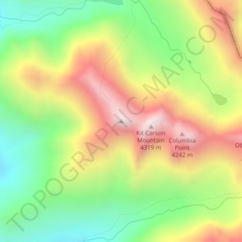
Nombre: Mapa topográfico Challenger Point, altitud, relieve.
Lugar: Challenger Point, Saguache County, Colorado, United States (37.98023 -105.60673 37.98033 -105.60663)
Altitud media: 3.781 m
Altitud mínima: 3.338 m
Altitud máxima: 4.314 m
Haz una donación
Equípate para tu próxima aventura:
Como asociado de Amazon, este sitio gana comisiones por las compras que califican, sin ningún costo adicional para usted.
Otros mapas topográficos
Haga clic en un mapa para ver su topografía, su altitud y su relieve.
Great Sand Dunes National Park
United States > Colorado > Saguache County
In 1848, John C. Frémont was hired to find a railroad route from St. Louis to California. He crossed the Sangre de Cristos into the San Luis Valley in winter, courting disaster but proving that a winter crossing of this range was possible. He was followed in 1853 by Captain John Gunnison of the Corps of…
Altitud media: 2.616 m
Great Sand Dunes National Preserve
United States > Colorado > Saguache County
In 1848, John C. Frémont was hired to find a railroad route from St. Louis to California. He crossed the Sangre de Cristos into the San Luis Valley in winter, courting disaster but proving that a winter crossing of this range was possible. He was followed in 1853 by Captain John Gunnison of the Corps of…
Altitud media: 2.792 m
Haz una donación
Equípate para tu próxima aventura:
Como asociado de Amazon, este sitio gana comisiones por las compras que califican, sin ningún costo adicional para usted.
Great Sand Dunes National Park
United States > Colorado > Saguache County
In 1848, John C. Frémont was hired to find a railroad route from St. Louis to California. He crossed the Sangre de Cristos into the San Luis Valley in winter, courting disaster but proving that a winter crossing of this range was possible. He was followed in 1853 by Captain John Gunnison of the Corps of…
Altitud media: 2.616 m