
Haz una donación
Equípate para tu próxima aventura:
Como asociado de Amazon, este sitio gana comisiones por las compras que califican, sin ningún costo adicional para usted.
Mapa topográfico Treeville
Haga clic en el mapa para ver la altitud.
Haz una donación
Equípate para tu próxima aventura:
Como asociado de Amazon, este sitio gana comisiones por las compras que califican, sin ningún costo adicional para usted.
Acerca de este mapa
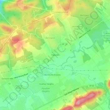
Nombre: Mapa topográfico Treeville, altitud, relieve.
Altitud media: 319 m
Altitud mínima: 257 m
Altitud máxima: 404 m
Haz una donación
Equípate para tu próxima aventura:
Como asociado de Amazon, este sitio gana comisiones por las compras que califican, sin ningún costo adicional para usted.
Otros mapas topográficos
Haga clic en un mapa para ver su topografía, su altitud y su relieve.
Knoxville
United States > Tennessee > Knox County
Knoxville features a diverse topography characterized by its position in the Great Appalachian Valley. The city sits at an elevation of approximately 886 feet above sea level, nestled between the Great Smoky Mountains to the east and the Cumberland Plateau to the west. This geographical setup results in a…
Altitud media: 307 m
Knoxville
United States > Tennessee > Knox County
According to the United States Census Bureau, the city has a total area of 104.2 square miles (269.8 km2), of which 98.5 square miles (255.2 km2) is land and 5.6 square miles (14.6 km2), or 5.42%, is water. Elevations range from just over 800 feet (240 m) along the riverfront to just over 1,000 feet (300 m) on…
Altitud media: 307 m
Haz una donación
Equípate para tu próxima aventura:
Como asociado de Amazon, este sitio gana comisiones por las compras que califican, sin ningún costo adicional para usted.
Halls Crossroads
United States > Tennessee > Knox County
It is located at 36°04′49″N 83°56′33″W / 36.08028°N 83.94250°W / 36.08028; -83.94250. It has an elevation of 1,040 feet.
Altitud media: 346 m
Haz una donación
Equípate para tu próxima aventura:
Como asociado de Amazon, este sitio gana comisiones por las compras que califican, sin ningún costo adicional para usted.
Victor Ashe Park
United States > Tennessee > Knox County > Knoxville > Windsor Park
Altitud media: 314 m
Knoxville
United States > Tennessee > Knox County
According to the United States Census Bureau, the city has a total area of 104.2 square miles (269.8 km2), of which 98.5 square miles (255.2 km2) is land and 5.6 square miles (14.6 km2), or 5.42%, is water. Elevations range from just over 800 feet (240 m) along the riverfront to just over 1,000 feet (300 m) on…
Altitud media: 307 m
House Mountain
United States > Tennessee > Knox County
House Mountain is a mountain located in Corryton, Tennessee, United States, about 8 miles (13 km) northeast of Knoxville. Rising to an elevation of 2,064 feet (629 m) above sea level, House Mountain is the highest point in Knox County.
Altitud media: 394 m
Haz una donación
Equípate para tu próxima aventura:
Como asociado de Amazon, este sitio gana comisiones por las compras que califican, sin ningún costo adicional para usted.
Knoxville
United States > Tennessee > Knox County
According to the United States Census Bureau, the city has a total area of 104.2 square miles (269.8 km2), of which 98.5 square miles (255.2 km2) is land and 5.6 square miles (14.6 km2), or 5.42%, is water. Elevations range from just over 800 feet (240 m) along the riverfront to just over 1,000 feet (300 m) on…
Altitud media: 307 m
Halls Crossroads
United States > Tennessee > Knox County
It is located at 36°04′49″N 83°56′33″W / 36.08028°N 83.94250°W / 36.08028; -83.94250. It has an elevation of 1,040 feet.
Altitud media: 346 m
Haz una donación
Equípate para tu próxima aventura:
Como asociado de Amazon, este sitio gana comisiones por las compras que califican, sin ningún costo adicional para usted.