
Mapa topográfico Selånger District
Mapa interactivo
Haga clic en el mapa para ver la altitud.
Acerca de este mapa
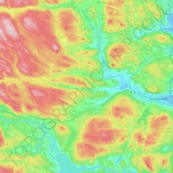
Nombre: Mapa topográfico Selånger District, altitud, relieve.
Altitud media: 135 m
Altitud mínima: -2 m
Altitud máxima: 359 m
Otros mapas topográficos
Haga clic en un mapa para ver su topografía, su altitud y su relieve.
Sandslån
Sweden > Västernorrland County > Ytterlännäs District
Sandslån, Ytterlännäs District, Kramfors kommun, Västernorrland County, Sweden
Altitud media: 11 m