
Mapa topográfico Oberelsbach
Mapa interactivo
Haga clic en el mapa para ver la altitud.
Acerca de este mapa
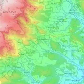
Nombre: Mapa topográfico Oberelsbach, altitud, relieve.
Lugar: Oberelsbach, Landkreis Rhön-Grabfeld, Bavière, 97656, Allemagne (50.39151 9.98800 50.48189 10.16309)
Altitud media: 472 m
Altitud mínima: 275 m
Altitud máxima: 902 m
Otros mapas topográficos
Haga clic en un mapa para ver su topografía, su altitud y su relieve.
Frankenheim
Allemagne > Bavière > Landkreis Rhön-Grabfeld > Bischofsheim i.d.Rhön
Frankenheim, Bischofsheim i.d.Rhön, Landkreis Rhön-Grabfeld, Bavière, 97653, Allemagne
Altitud media: 599 m
Hendungen
Allemagne > Bavière > Landkreis Rhön-Grabfeld
Hendungen, Mellrichstadt (VGem), Landkreis Rhön-Grabfeld, Bavière, Allemagne
Altitud media: 341 m
Ostheim v.d.Rhön
Allemagne > Bavière > Landkreis Rhön-Grabfeld
Ostheim v.d.Rhön, Ostheim vor der Rhön (VGem), Landkreis Rhön-Grabfeld, Bavière, 97645, Allemagne
Altitud media: 369 m
Ostheim vor der Rhön (VGem)
Allemagne > Bavière > Landkreis Rhön-Grabfeld
Ostheim vor der Rhön (VGem), Landkreis Rhön-Grabfeld, Bavière, 97645, Allemagne
Altitud media: 529 m
Bischofsheim in der Rhön
Allemagne > Bavière > Landkreis Rhön-Grabfeld > Bischofsheim i.d.Rhön > Bischofsheim in der Rhön
Bischofsheim in der Rhön, Bischofsheim i.d.Rhön, Landkreis Rhön-Grabfeld, Bavière, 97653, Allemagne
Altitud media: 609 m
Bischofsheim i.d.Rhön
Allemagne > Bavière > Landkreis Rhön-Grabfeld
Bischofsheim i.d.Rhön, Landkreis Rhön-Grabfeld, Bavière, Allemagne
Altitud media: 597 m